File:Map of the Nyon Conference.svg
Jump to navigation
Jump to search

Size of this PNG preview of this SVG file: 799 × 314 pixels. Other resolutions: 320 × 126 pixels | 640 × 252 pixels | 1,024 × 402 pixels | 1,280 × 503 pixels | 2,560 × 1,006 pixels | 1,837 × 722 pixels.
Original file (SVG file, nominally 1,837 × 722 pixels, file size: 59 KB)
Captions
Captions
Add a one-line explanation of what this file represents
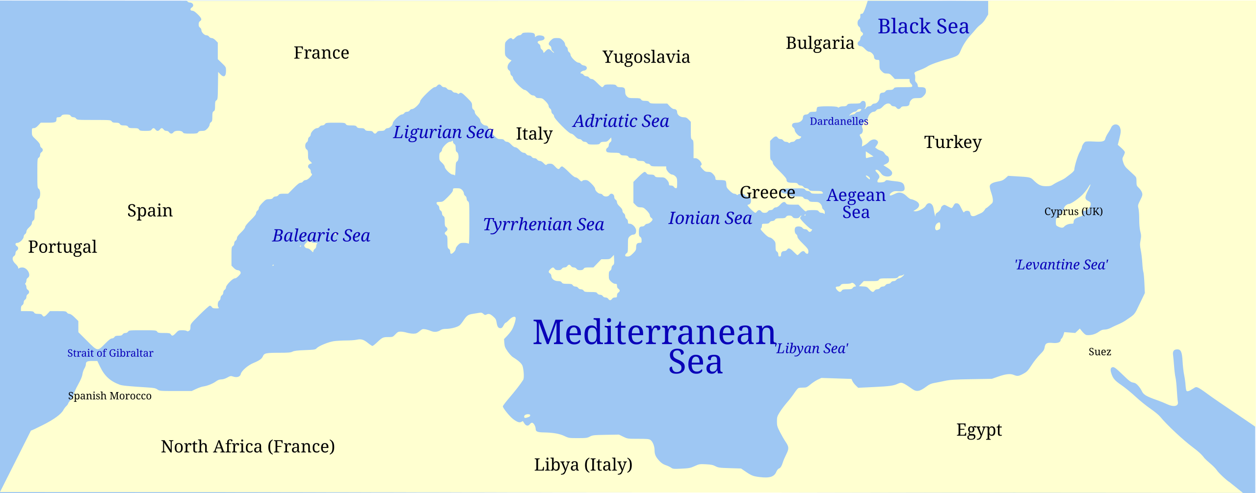
| Description | Map of the Mediterranean Sea and subdivisions. Marked are subdivisions according to the International Hydrographic Organization, and countries and other places relevant to the 1937 Nyon Conference. |
| Date | (UTC) |
| Source | |
| Author |
|
I, the copyright holder of this work, hereby publish it under the following licenses:
| This file is licensed under the Creative Commons Attribution-Share Alike 3.0 Unported license. | ||
| ||
| This licensing tag was added to this file as part of the GFDL licensing update. |

|
Permission is granted to copy, distribute and/or modify this document under the terms of the GNU Free Documentation License, Version 1.2 or any later version published by the Free Software Foundation; with no Invariant Sections, no Front-Cover Texts, and no Back-Cover Texts. A copy of the license is included in the section entitled GNU Free Documentation License. |
You may select the license of your choice.
Original upload log[edit]
This image is a derivative work of the following images:
- File:Map_of_the_Mediterranean_and_subdivisions.svg licensed with Cc-by-sa-3.0-migrated, GFDL
- 2011-06-01T15:03:35Z Grandiose 1837x722 (56233 Bytes) {{Information |Description=Map of the Mediterranean Sea and subdivisions. Marked are subdivisions according to the International Hydrographic Organization. Some additional seas are marked in quotes, which are commonly used bu
Uploaded with derivativeFX
File history
Click on a date/time to view the file as it appeared at that time.
| Date/Time | Thumbnail | Dimensions | User | Comment | |
|---|---|---|---|---|---|
| current | 18:31, 1 June 2011 | 1,837 × 722 (59 KB) | Grandiose (talk | contribs) | {{Information |Description=Map of the Mediterranean Sea and subdivisions. Marked are subdivisions according to the International Hydrographic Organization, and countries and other places relevant to the 1937 Nyon Conference. |Source=*[[:File:Map_of_the_Me |
You cannot overwrite this file.
File usage on Commons
There are no pages that use this file.
File usage on other wikis
The following other wikis use this file:
- Usage on ban.wikipedia.org
- Usage on gl.wikipedia.org