File:Map of the Niger Country in 1898.jpg
Jump to navigation
Jump to search

Size of this preview: 800 × 423 pixels. Other resolutions: 320 × 169 pixels | 640 × 339 pixels | 1,024 × 542 pixels | 1,280 × 677 pixels | 3,760 × 1,989 pixels.
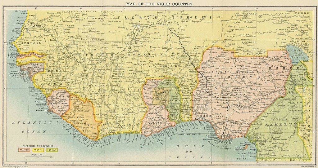
Original file (3,760 × 1,989 pixels, file size: 694 KB, MIME type: image/jpeg)
Captions
Captions
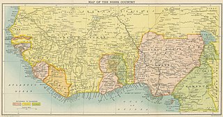
Map of the West Africa in 1898
Summary[edit]
| Description |
English: Map of West Africa from "In the Niger Country" by Harold Bindloss (Edinburgh: W. Blackwood & Sons, 1898)
Available at the British Library http://access.bl.uk/item/viewer/ark:/81055/vdc_00000005A102 less |
| Date | |
| Source |
BINDLOSS, Harold, In the Niger Country ... With two maps, (Edinburgh: W. Blackwood & Sons, 1898) http://access.bl.uk/item/viewer/ark:/81055/vdc_00000005A102 |
| Author | Book by Harold Bindloss, Map by John Bartholomew and Co |
Licensing[edit]
|
This work is in the public domain in its country of origin and other countries and areas where the copyright term is the author's life plus 70 years or fewer. This work is in the public domain in the United States because it was published (or registered with the U.S. Copyright Office) before January 1, 1929. | |
| This file has been identified as being free of known restrictions under copyright law, including all related and neighboring rights. | |
File history
Click on a date/time to view the file as it appeared at that time.
| Date/Time | Thumbnail | Dimensions | User | Comment | |
|---|---|---|---|---|---|
| current | 09:32, 22 September 2020 | | 3,760 × 1,989 (694 KB) | Johncosgrave (talk | contribs) | Uploaded a work by Book by Harold Bindloss, Map by John Bartholomew and Co from BINDLOSS, Harold, In the Niger Country ... With two maps, (Edinburgh: W. Blackwood & Sons, 1898) http://access.bl.uk/item/viewer/ark:/81055/vdc_00000005A102 with UploadWizard |
You cannot overwrite this file.
File usage on Commons
There are no pages that use this file.
File usage on other wikis
The following other wikis use this file:
- Usage on en.wikipedia.org