File:Map of the Karabakh Khanate 2.svg
Jump to navigation
Jump to search

Size of this PNG preview of this SVG file: 741 × 599 pixels. Other resolutions: 297 × 240 pixels | 594 × 480 pixels | 950 × 768 pixels | 1,266 × 1,024 pixels | 2,532 × 2,048 pixels | 1,711 × 1,384 pixels.
Original file (SVG file, nominally 1,711 × 1,384 pixels, file size: 1.28 MB)
Captions
Captions
Map of the Karabakh Khanate 2
Summary[edit]
| Description |
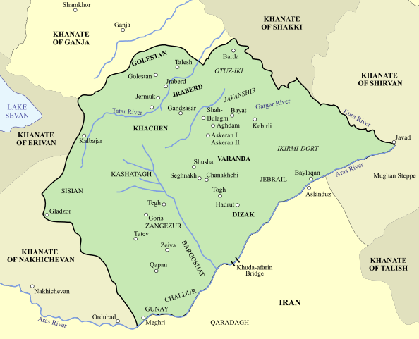
English: Map of the Karabakh Khanate, a khanate under Iranian and later Russian suzerainty, which controlled the historical region of Karabakh, now divided between modern-day Armenia and Azerbaijan. |
| Date | |
| Source | Own work a modified version of https://commons.wikimedia.org/wiki/File:Map_of_the_Karabakh_Khanate.svg, by HistoryofIran based on Based on the map in Bournoutian, George (1994). A History of Qarabagh: An Annotated Translation of Mirza Jamal Javanshir Qarabaghi's Tarikh-e Qarabagh, page 25 |
| Author | Amitchell125 |
| Other versions | [File:Map of the Karabakh Khanate.svg] |
Licensing[edit]
I, the copyright holder of this work, hereby publish it under the following license:
This file is licensed under the Creative Commons Attribution-Share Alike 4.0 International license.
- You are free:
- to share – to copy, distribute and transmit the work
- to remix – to adapt the work
- Under the following conditions:
- attribution – You must give appropriate credit, provide a link to the license, and indicate if changes were made. You may do so in any reasonable manner, but not in any way that suggests the licensor endorses you or your use.
- share alike – If you remix, transform, or build upon the material, you must distribute your contributions under the same or compatible license as the original.
File history
Click on a date/time to view the file as it appeared at that time.
| Date/Time | Thumbnail | Dimensions | User | Comment | |
|---|---|---|---|---|---|
| current | 14:46, 25 August 2023 | | 1,711 × 1,384 (1.28 MB) | Amitchell125 (talk | contribs) | Uploaded own work with UploadWizard |
You cannot overwrite this file.
File usage on Commons
The following page uses this file:
Metadata
Categories:
- SVG maps of the history of Azerbaijan
- Maps of the history of Armenia
- Maps of the history of the south Caucasus region
- Maps of the history of the Caucasus
- Maps of Khanates of the South Caucasus
- George Bournoutian
- Maps of the history of Iran
- English-language SVG maps showing history
- Maps showing 18th-century history
- Khanate of Karabakh