File:Map of the European Parliament election (2009) (United Kingdom).svg
Jump to navigation
Jump to search

Size of this PNG preview of this SVG file: 375 × 600 pixels. Other resolutions: 150 × 240 pixels | 300 × 480 pixels | 480 × 768 pixels | 640 × 1,024 pixels | 1,280 × 2,048 pixels | 500 × 800 pixels.
Original file (SVG file, nominally 500 × 800 pixels, file size: 238 KB)
Captions
Captions
Add a one-line explanation of what this file represents
Summary[edit]
| Description |
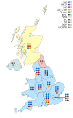
English: Map of the results for the European Parliament election, 2009 in the United Kingdom. Data is from: BBC News. |
||
| Date | |||
| Source | Own work | ||
| Author | JDuggan101 | ||
| Permission (Reusing this file) |
|
||
| SVG development |

_(United_Kingdom).svg&action=edit§ion=1)
File history
Click on a date/time to view the file as it appeared at that time.
| Date/Time | Thumbnail | Dimensions | User | Comment | |
|---|---|---|---|---|---|
| current | 12:36, 22 June 2019 | | 500 × 800 (238 KB) | SD604 (talk | contribs) | Updated to new format. |
| 14:01, 6 June 2019 |  | 575 × 575 (795 KB) | RaviC (talk | contribs) | fixed numbers | |
| 16:14, 26 May 2019 |  | 575 × 575 (794 KB) | RaviC (talk | contribs) | indicated the alliance between the Conservatives and UCUNF | |
| 11:40, 20 October 2018 |  | 575 × 575 (781 KB) | SD604 (talk | contribs) | {{Information |description ={{en|1=Map of the results for the European Parliament election, 2009 in the United Kingdom. Data is from: [http://news.bbc.co.uk/1/shared/bsp/hi/elections/euro/09/html/ukregion_999999.stm BBC News.]}}}} |date =2018-10-19 |source ={{own}} |author =[https://en.wikipedia.org/wiki/User:JDuggan101 User:JDuggan101] |permission ={{PD-user-en|JDuggan101}} }} Category:Maps of the United Kingdom |
You cannot overwrite this file.
File usage on Commons
The following 5 pages use this file:
_(United_Kindgdom).svg&redirect=no)
File usage on other wikis
The following other wikis use this file:
- Usage on en.wikipedia.org
- Usage on fr.wikipedia.org
_(United_Kingdom).svg&oldid=719184512)