File:Map of the Caracas metro.png
Jump to navigation
Jump to search

Size of this preview: 800 × 474 pixels. Other resolutions: 320 × 189 pixels | 640 × 379 pixels | 1,024 × 606 pixels | 1,280 × 758 pixels | 3,123 × 1,849 pixels.
Original file (3,123 × 1,849 pixels, file size: 6.09 MB, MIME type: image/png)
Captions
Captions
Add a one-line explanation of what this file represents
{{Information |Description=
| Description |
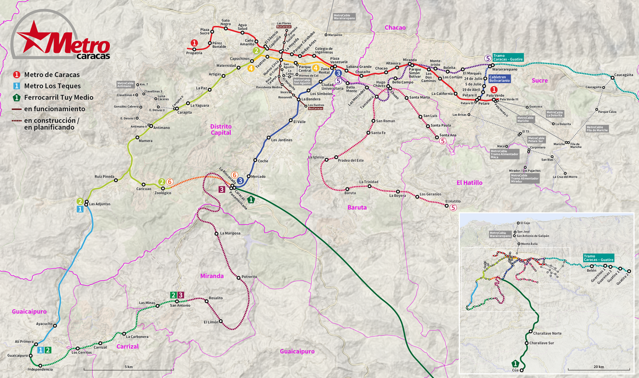
Deutsch: Karte der Metro Caracas
English: Map of the Caracas metro
Español: Mapa del Metro de Caracas
Français : Plan du métro de Caracas |
| Date | see file history |
| Source | Own work, using SRTM data for the relief information and Openstreetmap data for the street network in the background |
| Author | Maximilian Dörrbecker (Chumwa) |
| Permission (Reusing this file) |
All OpenStreetMap data and maps are Creative Commons "CC-BY-SA 2.0" licensed This file is licensed under the Creative Commons Attribution-Share Alike 2.0 Generic license.
|
File history
Click on a date/time to view the file as it appeared at that time.
| Date/Time | Thumbnail | Dimensions | User | Comment | |
|---|---|---|---|---|---|
| current | 17:14, 31 December 2016 | | 3,123 × 1,849 (6.09 MB) | Chumwa (talk | contribs) | |
| 07:00, 29 November 2016 |  | 3,123 × 1,849 (6.02 MB) | Chumwa (talk | contribs) | ||
| 22:33, 28 November 2016 |  | 3,123 × 1,849 (6 MB) | Chumwa (talk | contribs) | ||
| 21:41, 28 November 2016 |  | 3,123 × 1,849 (6.06 MB) | Chumwa (talk | contribs) | {{Information |Description= {{Information |Description= {{de|Karte der Metro Caracas}} {{en|Map of the Caracas metro}} {{es|Mapa del Metro de Caracas}} {{fr|Plan du métro de Caracas}} |Author=Maximilian Dörrbecker ([[:de:User:Chum... |
You cannot overwrite this file.
File usage on Commons
The following 12 pages use this file:
- Caracas
- Caracas Metro
- User:Chumwa/Gallery
- User:Chumwa/OgreBot/Potential transport maps/2016 December 21-31
- User:Chumwa/OgreBot/Potential transport maps/2016 November 21-30
- User:Chumwa/OgreBot/Public transport information/2016 December 21-31
- User:Chumwa/OgreBot/Public transport information/2016 November 21-30
- User:Chumwa/OgreBot/Transport Maps/2016 December 21-31
- User:Chumwa/OgreBot/Transport Maps/2016 November 21-30
- User:Chumwa/OgreBot/Travel and communication maps/2016 December 21-31
- User:Chumwa/OgreBot/Travel and communication maps/2016 November 21-30
- Category:Caracas Metro
File usage on other wikis
The following other wikis use this file:
- Usage on ca.wikipedia.org
- Usage on de.wikipedia.org
- Usage on de.wikivoyage.org
- Usage on en.wikipedia.org
- Usage on eo.wikipedia.org
- Usage on es.wikipedia.org
- Usage on eu.wikipedia.org
- Usage on fa.wikipedia.org
- Usage on fi.wikipedia.org
- Usage on fr.wikipedia.org
- Usage on he.wikivoyage.org
- Usage on hu.wikipedia.org
- Usage on it.wikipedia.org
- Usage on ja.wikipedia.org
- Usage on ka.wikipedia.org
- Usage on nl.wikipedia.org
- Usage on pt.wikipedia.org
- Usage on ru.wikipedia.org
- Usage on tr.wikipedia.org
- Usage on uz.wikipedia.org
- Usage on www.wikidata.org
- Usage on zh.wikipedia.org