File:Map of territorial growth 1775-es.svg
From Wikimedia Commons, the free media repository
Jump to navigation
Jump to search

Size of this PNG preview of this SVG file: 458 × 599 pixels. Other resolutions: 183 × 240 pixels | 367 × 480 pixels | 587 × 768 pixels | 783 × 1,024 pixels | 1,565 × 2,048 pixels | 506 × 662 pixels.
Original file (SVG file, nominally 506 × 662 pixels, file size: 229 KB)
File information
Structured data
Captions
Captions
Add a one-line explanation of what this file represents
Summary[edit]
| DescriptionMap of territorial growth 1775-es.svg |
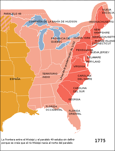
Español: Las Trece Colonias americanas, la provincia de Quebec y el Territorio Indio según el decreto real de 1763. Deutsch: Östliches Nordamerika im Jahre 1775 mit den vom Königreich Großbritannien kontrollierten Provinz Quebec und den dreizehn Kolonien an der Küste sowie dem von diesen durch die Proklamationslinie von 1763 abgeschiedene Indian Reserve (siehe auch: Britische Kolonisierung Amerikas).
English: Eastern North America in 1775: The British Province of Quebec, the British thirteen colonies on the Atlantic coast and the Indian Reserve (as of the Royal Proclamation of 1763).
Italiano: Nel 1775, l'Inghilterra aveva il dominio sulle zone indicate in rosso e rosa sulla mappa e la Spagna su quelle arancione. La zona rossa è quella relativa alle 13 colonie aperte agli insediamenti dopo la proclamazione del 1763. |
| Date | |
| Source |
This file was derived from: Map of territorial growth 1775.svg:  |
| Author |
|
Licensing[edit]
I, the copyright holder of this work, hereby publish it under the following license:
This file is licensed under the Creative Commons Attribution-Share Alike 3.0 Unported license.
- You are free:
- to share – to copy, distribute and transmit the work
- to remix – to adapt the work
- Under the following conditions:
- attribution – You must give appropriate credit, provide a link to the license, and indicate if changes were made. You may do so in any reasonable manner, but not in any way that suggests the licensor endorses you or your use.
- share alike – If you remix, transform, or build upon the material, you must distribute your contributions under the same or compatible license as the original.
File history
Click on a date/time to view the file as it appeared at that time.
| Date/Time | Thumbnail | Dimensions | User | Comment | |
|---|---|---|---|---|---|
| current | 05:48, 3 March 2023 |  | 506 × 662 (229 KB) | Johnn Francis (talk | contribs) | Reverted to version as of 16:20, 18 October 2012 (UTC) Este mapa describe la situación en el año 1775. Florida fue adquirida por Gran Bretaña en 1763 de España (quien volvería a adquirirla en 1783). Por lo tanto, Florida (tanto el oeste como el este) era británica en el momento en que se establece este mapa. |
| 16:36, 19 December 2022 |  | 506 × 662 (223 KB) | PatriaDeTodos (talk | contribs) | Florida fue española entre 1513 y 1821 | |
| 16:20, 18 October 2012 |  | 506 × 662 (229 KB) | Rowanwindwhistler (talk | contribs) | User created page with UploadWizard |
You cannot overwrite this file.
File usage on Commons
The following 4 pages use this file:
File usage on other wikis
The following other wikis use this file:
- Usage on es.wikipedia.org
Metadata
This file contains additional information such as Exif metadata which may have been added by the digital camera, scanner, or software program used to create or digitize it. If the file has been modified from its original state, some details such as the timestamp may not fully reflect those of the original file. The timestamp is only as accurate as the clock in the camera, and it may be completely wrong.
| Width | 505.8125 |
|---|---|
| Height | 661.90625 |