File:Map of south-west England shown within England (Met Office region).png
Jump to navigation
Jump to search

Size of this preview: 526 × 600 pixels. Other resolutions: 210 × 240 pixels | 421 × 480 pixels | 674 × 768 pixels | 898 × 1,024 pixels | 2,400 × 2,736 pixels.
Original file (2,400 × 2,736 pixels, file size: 152 KB, MIME type: image/png)
Captions
Captions
Add a one-line explanation of what this file represents
| Description |
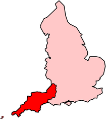
English: A map of south-west England as defined by the Met Office when describing the climate of south-west England. The counties included are: Cornwall, Devon, Somerset, North Somerset, Bath and North East Somerset, South Gloucestershire and the City of Bristol. The Isles of Scilly are also included in the region. |
| Date | |
| Source | File:BlankMap-EnglandSubdivisions.svg (a vectorised version of File:BlankMap-EnglandSubdivisions.png) and the Isles of Scilly were taken from File:H1N1 United Kingdom Map - Region 2.svg. They were all merged and modified on Inkscape. |
| Author |
|
| Other versions | Vector |
.svg)
Licensing[edit]
.png&action=edit§ion=1)
| This file is licensed under the Creative Commons Attribution-Share Alike 3.0 Unported license. Subject to disclaimers. | ||
| ||
| This licensing tag was added to this file as part of the GFDL licensing update. |

|
Permission is granted to copy, distribute and/or modify this document under the terms of the GNU Free Documentation License, Version 1.2 or any later version published by the Free Software Foundation; with no Invariant Sections, no Front-Cover Texts, and no Back-Cover Texts. A copy of the license is included in the section entitled GNU Free Documentation License. Subject to disclaimers. |
File history
Click on a date/time to view the file as it appeared at that time.
| Date/Time | Thumbnail | Dimensions | User | Comment | |
|---|---|---|---|---|---|
| current | 13:08, 15 December 2011 | | 2,400 × 2,736 (152 KB) | Mayhaymate (talk | contribs) | Optimized with PNGOUT |
| 01:11, 24 September 2009 |  | 2,400 × 2,736 (168 KB) | Extremepro (talk | contribs) | compressed file with en:pngcrush | |
| 23:42, 31 July 2009 |  | 2,400 × 2,736 (194 KB) | Jolly Janner (talk | contribs) | Vectorised the Isles of Scilly and cleaned up other crap. | |
| 03:44, 31 July 2009 |  | 2,400 × 2,736 (191 KB) | Jolly Janner (talk | contribs) | Quarter of the dimensions (4^2 less pixels) | |
| 03:24, 31 July 2009 |  | 9,600 × 10,945 (1.12 MB) | Jolly Janner (talk | contribs) | {{Information |Description={{en|1=A map of south-west England as defined by the Met Office when describing the climate of south-west England. The counties included are: Cornwall, [[w:Devo |
You cannot overwrite this file.
File usage on Commons
There are no pages that use this file.
.png&oldid=459413473)