File:Map of proposed Edinburgh Gateway station (annotated).jpg
Jump to navigation
Jump to search

Size of this preview: 727 × 600 pixels. Other resolutions: 291 × 240 pixels | 582 × 480 pixels | 931 × 768 pixels | 1,050 × 866 pixels.
Original file (1,050 × 866 pixels, file size: 371 KB, MIME type: image/jpeg)
Captions
Captions
Add a one-line explanation of what this file represents
| Description |
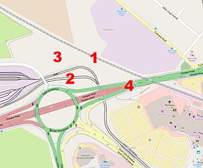
English: Map of the site of the proposed Edinburgh Gateway station, which will be sited west of the city, near the Gogar Roundabout (which links the A8 Glasgow Road and the A720 city bypass). Due to open in 2016, it will link the Fife-Edinburgh mainline railway (dotted line) with the Edinburgh Trams system (solid black line). The mainline platforms will be centred on 1., with the station concourse on the south side midway along them. A footbridge will connect the station building with the tram stop platforms, which will be sited at 2. (the tram main line and the railway line are separated by the tram depot spur, which leads to Gogar Tram Depot on the left). Road access will be via Myreton Bridge (the road heading north around the depot) into a pick-up/drop off point at 3., which will also feature bus stops. There will also be a pedestrian underpass to the Gyle Shopping Centre (bottom right), crossing the A8 at 4. |
|||
| Date | ||||
| Source | Annotation of File:Map of proposed Edinburgh Gateway station.jpg. | |||
| Author | Own work (annotation); OpenStreetMap contributors (base map) | |||
| Permission (Reusing this file) |
This file is licensed under the Creative Commons Attribution-Share Alike 2.0 Generic license.
|
| Object location | | View this and other nearby images on: OpenStreetMap |
|---|
.jpg¶ms=055.940607_N_-003.320679_E_globe:Earth_class:object_type:object_region:GB_&language=en)
File history
Click on a date/time to view the file as it appeared at that time.
| Date/Time | Thumbnail | Dimensions | User | Comment | |
|---|---|---|---|---|---|
| current | 21:54, 9 March 2015 | | 1,050 × 866 (371 KB) | Ultra7 (talk | contribs) | {{Information |Description={{en|Map of the site of the proposed Edinburgh Gateway station, which will be sited west of the city, near the Gogar Roundabout (which links the A8 Glasgow Road and the A720 city bypass... |
You cannot overwrite this file.
File usage on Commons
The following 4 pages use this file:
.jpg&oldid=859247130)