File:Map of pre World War II Germany TK25 Hemelingen 2919.jpg
Jump to navigation
Jump to search

Size of this preview: 746 × 599 pixels. Other resolutions: 299 × 240 pixels | 598 × 480 pixels | 956 × 768 pixels | 1,275 × 1,024 pixels | 2,549 × 2,048 pixels | 9,688 × 7,784 pixels.
Original file (9,688 × 7,784 pixels, file size: 20.5 MB, MIME type: image/jpeg)
Captions
Captions
Add a one-line explanation of what this file represents
| Warning | The original file is very high-resolution. It might not load properly or could cause your browser to freeze when opened at full size. |
|---|
Summary[edit]
| Description |
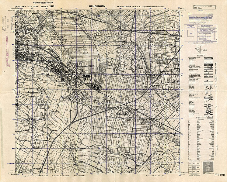
Deutsch: Maßstab 1:25.000, 3. Auflage von 1951 einer 1944 vom britischen de:War Office unter Verwendung eines deutschen Messtischblatts von 1934 erstellten Karte; zweisprachige Legende, Aktualisierungen gegenüber der deutschen Vorlage anhand Alliierter Luftaufnahmen English: Scale 1:25,000, 3rd edition of a map first edited in 1944 by the British War Office, based on a German survey map, with actualizations based on Allied air photos |
| Date | |
| Source |
http://lib.byu.edu/digital/germanmaps/ http://contentdm.lib.byu.edu/cdm/singleitem/collection/GermanyMaps/id/697/rec/1 Public Domain according to source: "Copyright Status/Owner -Public Domain, Courtesy Harold B. Lee Library, Brigham Young University". |
| Author | Great Britain: War Office; Germany: Reichsamt für Landesaufnahme |
| Other versions | the same sheet from 1925 in a rougher resolution, archived 2014 from digital archive of Universität Greifswald |
| This image is in the public domain according to German copyright law because it is part of a statute, ordinance, official decree or judgment (official work) issued by a German authority or court (§ 5 Abs.1 UrhG).
|
 |
File history
Click on a date/time to view the file as it appeared at that time.
| Date/Time | Thumbnail | Dimensions | User | Comment | |
|---|---|---|---|---|---|
| current | 16:49, 18 June 2012 | | 9,688 × 7,784 (20.5 MB) | Heinz-Josef Lücking (talk | contribs) | sw war verlustbehaftet |
| 21:19, 18 May 2012 |  | 9,688 × 7,784 (15.92 MB) | Heinz-Josef Lücking (talk | contribs) | S/W | |
| 21:10, 18 May 2012 |  | 9,688 × 7,784 (20.5 MB) | Heinz-Josef Lücking (talk | contribs) | Bildbearbeitung | |
| 20:58, 18 May 2012 |  | 9,688 × 7,784 (11.52 MB) | Heinz-Josef Lücking (talk | contribs) | {{Information |Description ={{de|1=Ein Satz von topographischen Karten vor dem Zweiten Weltkrieg Deutschland, ursprünglich von der deutschen Regierung gedruckt, wurden von den Briten und US-Militärs nach dem Krieg beschlagnahmt. Die meisten dieser... |
You cannot overwrite this file.
File usage on Commons
The following page uses this file:
File usage on other wikis
The following other wikis use this file:
- Usage on de.wikipedia.org