File:Map of chengdu.PNG
Jump to navigation
Jump to search

Size of this preview: 514 × 599 pixels. Other resolutions: 206 × 240 pixels | 519 × 605 pixels.
Original file (519 × 605 pixels, file size: 45 KB, MIME type: image/png)
Captions
Captions
Add a one-line explanation of what this file represents
| Description |
|
| Date | Commons upload by Shizhao 15:52, 20 May 2006 (UTC) |
| Source |
Originally from zh.wikipedia; description page is (was) here
|
| Author | User ???? on zh.wikipedia |
| Permission (Reusing this file) |
This file is licensed under the Creative Commons Attribution-Share Alike 2.0 Generic license.
|
File history
Click on a date/time to view the file as it appeared at that time.
| Date/Time | Thumbnail | Dimensions | User | Comment | |
|---|---|---|---|---|---|
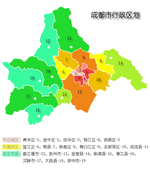
| current | 15:52, 20 May 2006 | | 519 × 605 (45 KB) | Shizhao (talk | contribs) | {{Information| |Description= *'''中心城区''':1)青羊区、2)金牛区、3)成华区、4)锦江区、5)武侯区 *'''外围城区''':6)温江区、7)郫县、8)新都区、9)青白江区、10)龙泉驿区、11)双流县 *'''郊区市县''':12 |
You cannot overwrite this file.
File usage on Commons
The following page uses this file: