File:Map of Watertown, Mass. - surveyed by order of the town, 1850 LOC 2012592608.jpg
Jump to navigation
Jump to search

Size of this preview: 737 × 600 pixels. Other resolutions: 295 × 240 pixels | 590 × 480 pixels | 944 × 768 pixels | 1,259 × 1,024 pixels | 2,517 × 2,048 pixels | 8,979 × 7,306 pixels.
Original file (8,979 × 7,306 pixels, file size: 8.11 MB, MIME type: image/jpeg)
Captions
Captions
Add a one-line explanation of what this file represents
Summary[edit]
| Description |
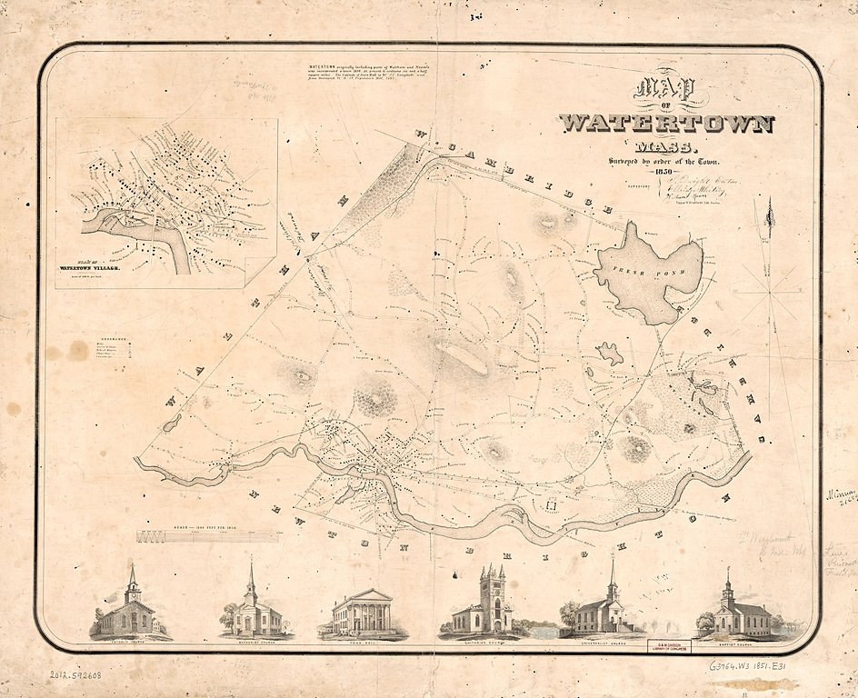
English: Relief shown by hachures. Cadastral map showing roads, drainage, landowners' names, school houses, churches, etc. Includes note, inset of "Plan of Watertown Village," and ill. (some hand col.). Available also through the Library of Congress Web site as a raster image. Dealer: Boston Rare Maps Acquisitions control no. 2009-070 |
||
| Title | Map of Watertown, Mass. : surveyed by order of the town, 1850 | ||
| Shelf ID | G3764.W3 1850 .E31 | ||
| Date | |||
| Source | https://www.loc.gov/item/2012592608/ | ||
| Author | Eaton, S. Dwight; Whiting, Ellridge; Mason, William; Tappan & Bradford | ||
| Permission (Reusing this file) |
|
||
| Other versions |
|
||
| Location | Watertown · United States · Massachusetts | ||
| Part of | American Memory · Cities And Towns · Catalog · Geography And Map Division | ||
| Subject | Cadastral Maps · United States · Watertown · Maps · Watertown (Mass.) · Massachusetts · Landowners |


Licensing[edit]
|
This is a faithful photographic reproduction of a two-dimensional, public domain work of art. The work of art itself is in the public domain for the following reason:
The official position taken by the Wikimedia Foundation is that "faithful reproductions of two-dimensional public domain works of art are public domain".
This photographic reproduction is therefore also considered to be in the public domain in the United States. In other jurisdictions, re-use of this content may be restricted; see Reuse of PD-Art photographs for details. | ||||
File history
Click on a date/time to view the file as it appeared at that time.
| Date/Time | Thumbnail | Dimensions | User | Comment | |
|---|---|---|---|---|---|
| current | 20:09, 25 May 2018 | | 8,979 × 7,306 (8.11 MB) | Fæ (talk | contribs) | LOC Maps https://www.loc.gov/item/2012592608/ #15144 |
You cannot overwrite this file.
File usage on Commons
The following page uses this file: