File:Map of USA by state lowerhouse.svg
Jump to navigation
Jump to search

Size of this PNG preview of this SVG file: 512 × 317 pixels. Other resolutions: 320 × 198 pixels | 640 × 396 pixels | 1,024 × 634 pixels | 1,280 × 793 pixels | 2,560 × 1,585 pixels.
Original file (SVG file, nominally 512 × 317 pixels, file size: 73 KB)
Captions
Captions
Add a one-line explanation of what this file represents
| Description |
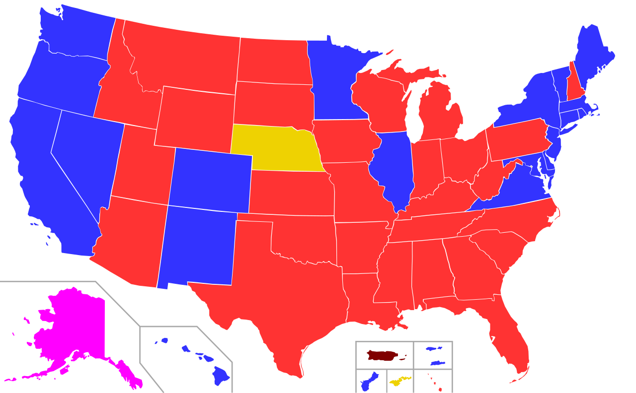
English: A map of the United States, showing which party controls each US state lower house. Information from File:States lower house political majority.png
Democrats
Republicans
Coalition government between Democrats, Republicans, and Independents, with the Speaker of the House being Independent
Popular Democrats
New Progressives
Nonpartisan legislature |
| Date | (UTC) |
| Source |
|
| Author |
|
This file is licensed under the Creative Commons Attribution-Share Alike 3.0 Unported license.
- You are free:
- to share – to copy, distribute and transmit the work
- to remix – to adapt the work
- Under the following conditions:
- attribution – You must give appropriate credit, provide a link to the license, and indicate if changes were made. You may do so in any reasonable manner, but not in any way that suggests the licensor endorses you or your use.
- share alike – If you remix, transform, or build upon the material, you must distribute your contributions under the same or compatible license as the original.
Original upload log[edit]
This image is a derivative work of the following images:
- File:Map_of_USA_by_state_upperhouse.svg licensed with Cc-by-sa-3.0,2.5,2.0,1.0, GFDL
- 2009-08-06T11:36:31Z Cassowary 932x569 (291571 Bytes) {{Information |Description=A map of the [[United States]], showing which party controls each US state upper house (and the unicameral Nebraskan legislature. Information from [[:w:File:States upper house political majority.png
- File:Blank US Map.svg licensed with Cc-by-sa-3.0, GFDL
File history
Click on a date/time to view the file as it appeared at that time.
| Date/Time | Thumbnail | Dimensions | User | Comment | |
|---|---|---|---|---|---|
| current | 15:00, 28 April 2021 | | 512 × 317 (73 KB) | ZaidRock11 (talk | contribs) | 2021 update (New Hampshire and Puerto Rico) |
| 19:38, 4 July 2020 |  | 512 × 317 (73 KB) | Thesavagenorwegian (talk | contribs) | All evidence points to Alaska's House still being coalition-controlled. | |
| 03:57, 8 January 2020 |  | 512 × 317 (73 KB) | Melvingatez34 (talk | contribs) | updated following 2019 elections | |
| 19:29, 4 June 2019 |  | 512 × 317 (71 KB) | Pharexia (talk | contribs) | removed labels for consistancy | |
| 18:17, 12 February 2019 |  | 959 × 593 (186 KB) | ZaidRock11 (talk | contribs) | January 2019 update | |
| 04:01, 17 January 2018 |  | 959 × 593 (186 KB) | AHC300 (talk | contribs) | Update | |
| 17:01, 2 June 2017 |  | 959 × 593 (187 KB) | ZaidRock11 (talk | contribs) | January 2017 update | |
| 13:13, 1 February 2015 |  | 959 × 593 (187 KB) | AHC300 (talk | contribs) | Minnesota Senate | |
| 21:05, 20 January 2015 |  | 959 × 593 (187 KB) | AHC300 (talk | contribs) | Update Jan. 2015 | |
| 01:58, 28 November 2014 |  | 959 × 593 (187 KB) | AHC300 (talk | contribs) | Guam fixed |
You cannot overwrite this file.
File usage on Commons
The following 7 pages use this file:
- User:Lokal Profil/Gallery/Map
- User:Magog the Ogre/Political maps/2019 February 10-18
- User:Magog the Ogre/Political maps/2019 June 1-10
- User:Magog the Ogre/Political maps/2020 January 1-10
- User:Magog the Ogre/Political maps/2020 July 1-10
- User:Magog the Ogre/Political maps/2021 April 21-30
- File:States lower house political majority.png
File usage on other wikis
The following other wikis use this file:
- Usage on en.wikipedia.org
- Usage on fr.wikipedia.org
- Usage on uk.wikipedia.org