File:Map of Toronto, 1878-04-01, drawn by A.T. Cotterell.jpeg

Original file (2,868 × 1,826 pixels, file size: 1.29 MB, MIME type: image/jpeg)
Captions
Captions
Summary[edit]
| Description |
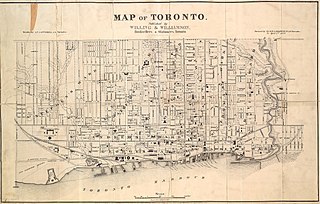
Original caption: " Map of Toronto, published by Willing & Williamson "
Drawn by A.T. Cotterell, C.E. Toronto. Revised by H.J. & W.A. Browne, P.L.S. Toronto to April 1, 1878 Image courtesy Toronto Public Library: T1878/4Msm See also: LAC MIKAN 4170046
|
|||
| Date | ||||
| Source | http://oldtorontomaps.blogspot.com/2013/01/1878-illustrated-historical-atlas-of.html | |||
| Author | Creator:A.T. Cotterell | |||
| Permission (Reusing this file) |
|


File history
Click on a date/time to view the file as it appeared at that time.
| Date/Time | Thumbnail | Dimensions | User | Comment | |
|---|---|---|---|---|---|
| current | 01:09, 4 November 2019 | | 2,868 × 1,826 (1.29 MB) | Geo Swan (talk | contribs) | {{Information |Description={{original caption|Map of Toronto, published by Willing & Williamson <p>Drawn by A.T. Cotterell, C.E. Toronto. <p>Revised by H.J. & W.A. Browne, P.L.S. Toronto to April 1, 1878 <p>Image courtesy Toronto Public Library: T1878/4Msm <p>See also: LAC MIKAN 4170046}} {{TPL|T1878/4Msm}} |Source=http://oldtorontomaps.blogspot.com/2013/01/1878-illustrated-historical-atlas-of.html |Date=1878-04-01 |Author={{Creator:A.T. Cotterell}} |Permission={{PD-Canada}} |other_versions=... |
You cannot overwrite this file.
File usage on Commons
There are no pages that use this file.