File:Map of Sanctuary Cities and Counties in the United States.svg
Jump to navigation
Jump to search

Size of this PNG preview of this SVG file: 800 × 507 pixels. Other resolutions: 320 × 203 pixels | 640 × 405 pixels | 1,024 × 649 pixels | 1,280 × 811 pixels | 2,560 × 1,621 pixels | 990 × 627 pixels.
Original file (SVG file, nominally 990 × 627 pixels, file size: 1.36 MB)
Captions
Captions
Add a one-line explanation of what this file represents
Summary[edit]
| Description |
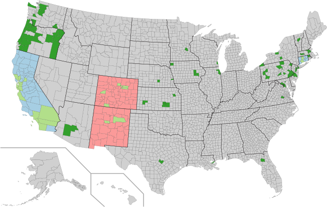
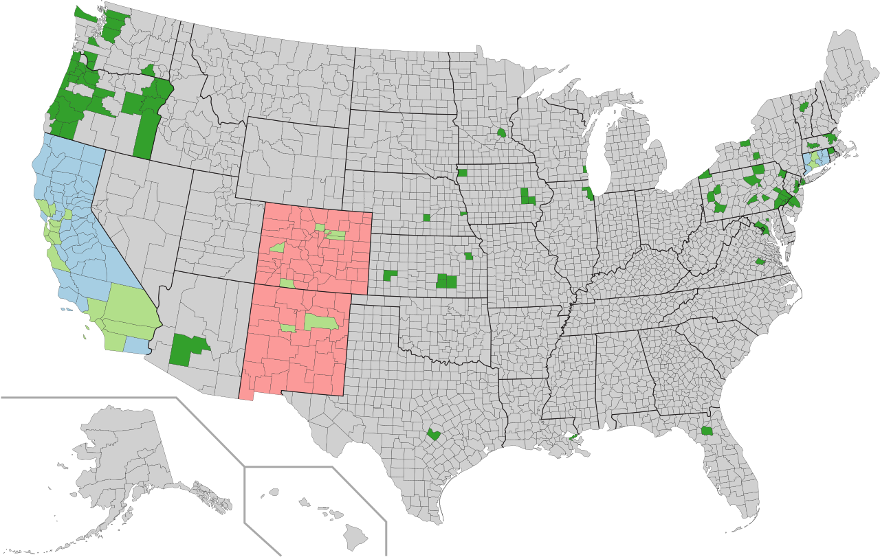
English: State has legislation in place that establishes a statewide sanctuary for illegal immigrants
County or county equivalent either contains a municipality that is a sanctuary for illegal immigrants, or is one itself
All county jails in the state do not honor ICE detainers
Alongside statewide legislation or policies establishing sanctuary for illegal immigrants, county contains a municipality that has policy or has taken action to further provide sanctuary to illegal immigrants
|
| Date |
Map: June 6, 2017 Data: January 2017 |
| Source | Own work |
| Author | WClarke |
Licensing[edit]
I, the copyright holder of this work, hereby publish it under the following license:
This file is licensed under the Creative Commons Attribution-Share Alike 4.0 International license.
- You are free:
- to share – to copy, distribute and transmit the work
- to remix – to adapt the work
- Under the following conditions:
- attribution – You must give appropriate credit, provide a link to the license, and indicate if changes were made. You may do so in any reasonable manner, but not in any way that suggests the licensor endorses you or your use.
- share alike – If you remix, transform, or build upon the material, you must distribute your contributions under the same or compatible license as the original.
File history
Click on a date/time to view the file as it appeared at that time.
| Date/Time | Thumbnail | Dimensions | User | Comment | |
|---|---|---|---|---|---|
| current | 05:38, 6 June 2017 | | 990 × 627 (1.36 MB) | WClarke (talk | contribs) | recreated map using data directly from Dept. of Homeland Security with color coding |
| 22:03, 25 April 2017 |  | 990 × 627 (1.36 MB) | WClarke (talk | contribs) | Reverted to version as of 05:35, 14 April 2017 (UTC) newest revision not rendered correctly by librsvg on pages | |
| 19:45, 17 April 2017 |  | 990 × 627 (1.36 MB) | WClarke (talk | contribs) | highlighted counties in "sanctuary states" in yellow | |
| 05:35, 14 April 2017 |  | 990 × 627 (1.36 MB) | WClarke (talk | contribs) | User created page with UploadWizard |
You cannot overwrite this file.
File usage on Commons
The following page uses this file:
File usage on other wikis
The following other wikis use this file:
- Usage on en.wikipedia.org