File:Map of Poland (1945).png
Jump to navigation
Jump to search
No higher resolution available.
Map_of_Poland_(1945).png (594 × 513 pixels, file size: 13 KB, MIME type: image/png)
Captions
Captions
Add a one-line explanation of what this file represents

|
This historical map image could be re-created using vector graphics as an SVG file. This has several advantages; see Commons:Media for cleanup for more information. If an SVG form of this image is available, please upload it and afterwards replace this template with
{{vector version available|new image name}}.
It is recommended to name the SVG file “Map of Poland (1945).svg”—then the template Vector version available (or Vva) does not need the new image name parameter. |
Summary[edit]
.png&action=edit§ion=1)
| Description |
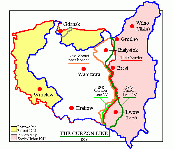
English: Map of Poland in 1945.
Deutsch: Karte Polens (1945). |
| Date | |
| Source | Own work (originally at en.wikipedia) |
| Author | Adam Carr |
| Other versions | Derivative works of this file: Polszczyzna kresowa.png |
Licensing[edit]
.png&action=edit§ion=2)
| |
This work has been released into the public domain by its author, Adam Carr, at the English Wikipedia project. This applies worldwide. In case this is not legally possible: |
File history
Click on a date/time to view the file as it appeared at that time.
| Date/Time | Thumbnail | Dimensions | User | Comment | |
|---|---|---|---|---|---|
| current | 18:29, 18 June 2018 | | 594 × 513 (13 KB) | Julieta39 (talk | contribs) | According with 1919 maps |
| 03:57, 30 June 2016 |  | 594 × 513 (15 KB) | Poeticbent (talk | contribs) | r/m dead space, spelling | |
| 07:58, 12 February 2007 |  | 617 × 513 (9 KB) | Unomano (talk | contribs) | Map of Poland in 1945, drawn by en:User: Adam Carr. From en:Image:Map of Poland (1945).png {{PD-user-w|en|English Wikipedia|Adam Carr}} Category:Maps of the history of Poland | |
| 14:43, 2 December 2005 |  | 617 × 513 (9 KB) | Thuresson (talk | contribs) | Map of Poland in 1945, drawn by User: Adam Carr. From en:Image:Map of Poland (1945).png {{PD-user-w|en|English Wikipedia|Adam Carr}} Category:Historical maps of Poland |
.png)
You cannot overwrite this file.
File usage on Commons
The following 9 pages use this file:
-pl-.png)
File usage on other wikis
The following other wikis use this file:
- Usage on ang.wikipedia.org
- Usage on ar.wikipedia.org
- Usage on be-tarask.wikipedia.org
- Usage on be.wikipedia.org
- Usage on bg.wikipedia.org
- Usage on ca.wikipedia.org
- Usage on cs.wikipedia.org
- Usage on de.wikibooks.org
- Usage on el.wikipedia.org
- Usage on en.wikipedia.org
- Polish People's Republic
- User:Adam Carr/My archive of original cartographic contributions
- History of German settlement in Central and Eastern Europe
- User:Landau7
- Talk:Flight and expulsion of Germans (1944–1950)/Archive 10
- Polish population transfers (1944–1946)
- User:TheNoiseBringer
- User:Halibutt/expulsion
- User:Falcaorib
- Usage on es.wikipedia.org
- Usage on fa.wikipedia.org
- Usage on fr.wikipedia.org
- Usage on id.wikipedia.org
- Usage on it.wikipedia.org
- Usage on kk.wikipedia.org
- Usage on lv.wikipedia.org
- Usage on nl.wikipedia.org
- Usage on pt.wikipedia.org
- Usage on ro.wikipedia.org
View more global usage of this file.
.png)
.png&oldid=838536705)