File:Map of Oregon and upper California from the surveys of John Charles Frémont and other authorities LOC 79692902.jpg
Jump to navigation
Jump to search

Size of this preview: 484 × 600 pixels. Other resolutions: 194 × 240 pixels | 387 × 480 pixels | 620 × 768 pixels | 826 × 1,024 pixels | 1,653 × 2,048 pixels | 4,955 × 6,139 pixels.
Original file (4,955 × 6,139 pixels, file size: 5.96 MB, MIME type: image/jpeg)
Captions
Captions
Add a one-line explanation of what this file represents
Summary
[edit]| Description |
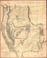
English: Scale 1:3,000,000. Hand colored. LC copy sectioned and mounted on cloth backing. Annotated on verso in black ink: California & Oregon 1848. Millard Fillmore. Relief shown by hachures and spot heights. Shows area of U.S. west of the Continental Divide. Available also through the Library of Congress Web site as a raster image. Includes notes and "Profile of the travelling route from the South Pass of the Rocky Mountains to the Bay of San Francisco." Vault AACR2 |
||
| Title | Map of Oregon and upper California from the surveys of John Charles Frémont and other authorities | ||
| Shelf ID | G4210 1848 .F72 | ||
| Date | |||
| Source | https://www.loc.gov/item/79692902/ | ||
| Author | Frémont, John Charles; Preuss, Charles; Fillmore, Millard; Edward Weber & Co.; United States. Congress. Senate | ||
| Permission (Reusing this file) |
|
||
| Other versions |
|
||
| Location | United States · West | ||
| Part of | American Memory · Catalog · Geography And Map Division · Discovery And Exploration | ||
| Subject | United States · Maps · West · West (U.S.) |

Licensing
[edit]
|
This is a faithful photographic reproduction of a two-dimensional, public domain work of art. The work of art itself is in the public domain for the following reason:
The official position taken by the Wikimedia Foundation is that "faithful reproductions of two-dimensional public domain works of art are public domain".
This photographic reproduction is therefore also considered to be in the public domain in the United States. In other jurisdictions, re-use of this content may be restricted; see Reuse of PD-Art photographs for details. | ||||
File history
Click on a date/time to view the file as it appeared at that time.
| Date/Time | Thumbnail | Dimensions | User | Comment | |
|---|---|---|---|---|---|
| current | 23:41, 24 May 2018 | | 4,955 × 6,139 (5.96 MB) | Fæ (talk | contribs) | LOC Maps https://www.loc.gov/item/79692902/ #14513 |
You cannot overwrite this file.
File usage on Commons
The following page uses this file: