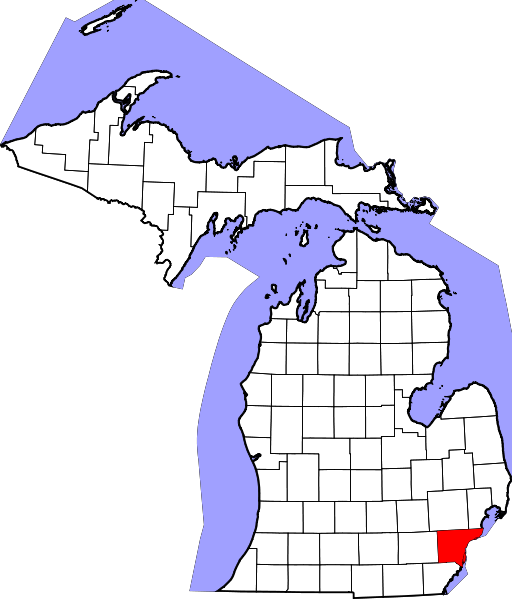
File:Map of Michigan highlighting Wayne County.svg
Jump to navigation
Jump to search

Size of this PNG preview of this SVG file: 512 × 599 pixels. Other resolutions: 205 × 240 pixels | 410 × 480 pixels | 656 × 768 pixels | 874 × 1,024 pixels | 1,749 × 2,048 pixels | 6,256 × 7,325 pixels.
Original file (SVG file, nominally 6,256 × 7,325 pixels, file size: 205 KB)
Captions
Captions
Add a one-line explanation of what this file represents
Summary[edit]
- Credits
- David Benbennick made this map.
- For more information, see Commons:United States county locator maps.
| I, the copyright holder of this work, release this work into the public domain. This applies worldwide. In some countries this may not be legally possible; if so: I grant anyone the right to use this work for any purpose, without any conditions, unless such conditions are required by law. |
File history
Click on a date/time to view the file as it appeared at that time.
| Date/Time | Thumbnail | Dimensions | User | Comment | |
|---|---|---|---|---|---|
| current | 13:01, 12 February 2006 | | 6,256 × 7,325 (205 KB) | David Benbennick (talk | contribs) | {{subst:User:Dbenbenn/clm|county=Wayne County|state=Michigan|type=county}} |
You cannot overwrite this file.
File usage on Commons
The following 10 pages use this file:
- Category:Births in Wayne County, Michigan
- Category:Deaths in Wayne County, Michigan
- Category:Maps of Wayne County, Michigan
- Category:Michigan State Historic Sites in Wayne County, Michigan
- Category:National Register of Historic Places in Wayne County, Michigan
- Category:People of Wayne County, Michigan
- Category:Populated places in Wayne County, Michigan
- Category:Transport in Wayne County, Michigan
- Category:Wayne County, Michigan
- Category:Wayne County, Michigan Image by CLight
File usage on other wikis
The following other wikis use this file:
- Usage on ar.wikipedia.org
- مقاطعة وين (ميشيغان)
- ديربورن (ميشيغان)
- ديترويت
- تايلور
- هامتراميك (ميتشيغان)
- ألين بارك
- بلفيل (ميشيغان)
- ديربورن هايتس
- إكروس
- فلات روك
- غاردن سيتي (ميشيغان)
- جبل طارق (ميشيغان)
- غروس بوينت فارمز
- غروس بوينت بارك
- غروس بوينت شورز
- غروس بوينت وودز
- غروس بوينت
- هاربر وودز
- هايلاند بارك (ميشيغان)
- إنكستر (ميشيغان)
- لينكولن بارك
- ليفونيا (ميشيغان)
- ميلفيندال
- نورثفيل
- بلايموث (ميشيغان)
- ريفر روغ
- ريفرفيو (ميشيغان)
- روكوود (ميشيغان)
- رومولوس (ميشيغان)
- ساوثغيت
- ترينتون (ميشيغان)
- واين (ميشيغان)
- ويستلاند
- وودهيفن
- وايندوت
- بلدة دينتون (ميشيغان)
- بلدة غروس لي (ميشيغان)
- بلدة هورون تشارتر (ميشيغان)
- بلدة نورثفيل (ميشيغان)
- بلدة بليموث (ميشيغان)
- بلدة ريدفورد (ميشيغان)
- بلدة سومبتر (ميشيغان)
- بلدة فان بيورين تشارتر (ميشيغان)
- قالب:مقاطعة وين (ميشيغان)
- Usage on azb.wikipedia.org
- Usage on be.wikipedia.org
- Usage on bg.wikipedia.org
- Usage on bpy.wikipedia.org
- Usage on ca.wikipedia.org
View more global usage of this file.