File:Map of Lydia ancient times-el.svg
Jump to navigation
Jump to search

Size of this PNG preview of this SVG file: 400 × 277 pixels. Other resolutions: 320 × 222 pixels | 640 × 443 pixels | 1,024 × 709 pixels | 1,280 × 886 pixels | 2,560 × 1,773 pixels.
Original file (SVG file, nominally 400 × 277 pixels, file size: 47 KB)
Captions
Captions
Add a one-line explanation of what this file represents
Summary[edit]
| Description |
Ελληνικά: Η Λυδία τον 6ο αιώνα π.Χ. |
| Date | |
| Source | File:Map of Lydia ancient times-en.svg |
| Author | Wolfymoza |
| Other versions |
[]
|


|
This SVG file contains embedded text that can be translated into your language, using any capable SVG editor, text editor or the SVG Translate tool. For more information see: About translating SVG files. |
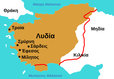
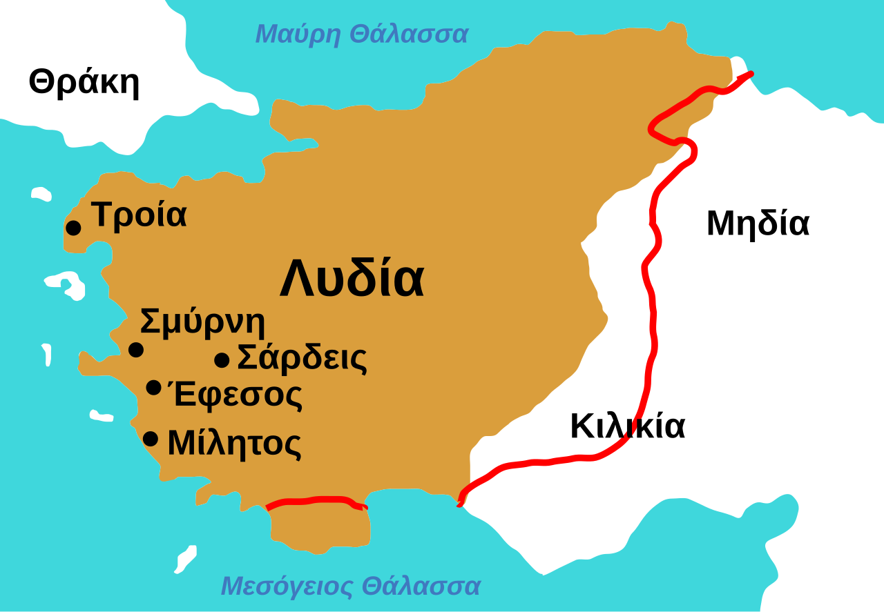
Το πορτοκαλί χρώμα είναι τα σύνορα της Λυδίας στα μέσα του 6ου αιώνα π.Χ. Η κόκκινη γραμμή είναι μια άλλη πιαθανή εκδοχή για τα σύνορά.
- Πληροφορίες από αυτούς τους χάρτες:
- Χάρτης 1 (πορτοκαλί):
- "μέσα του 6ου αιώνα εποχή του βασιλιά Κροίσου"
- Χάρτης 2 (κόκκινη γραμμή):
- "7ος αιώνα π.Χ. περίπου από το 690 ως το 546 π.Χ."
Licensing[edit]
I, the copyright holder of this work, hereby publish it under the following license:
This file is licensed under the Creative Commons Attribution-Share Alike 3.0 Unported license.
- You are free:
- to share – to copy, distribute and transmit the work
- to remix – to adapt the work
- Under the following conditions:
- attribution – You must give appropriate credit, provide a link to the license, and indicate if changes were made. You may do so in any reasonable manner, but not in any way that suggests the licensor endorses you or your use.
- share alike – If you remix, transform, or build upon the material, you must distribute your contributions under the same or compatible license as the original.
File history
Click on a date/time to view the file as it appeared at that time.
| Date/Time | Thumbnail | Dimensions | User | Comment | |
|---|---|---|---|---|---|
| current | 11:29, 19 June 2014 | | 400 × 277 (47 KB) | Wolfymoza (talk | contribs) | {{Information |Description ={{en|1=The edge of the brown area is the border of Lydia at the middle of the 6th century BC. The red line is a possible different border of Lydia.}} {{el|1=Το πορτοκαλί χρώμα είναι τα σύνορα... |
You cannot overwrite this file.
File usage on Commons
The following 22 pages use this file:
- File:Map of Lydia ancient times-2.jpg
- File:Map of Lydia ancient times-als.svg
- File:Map of Lydia ancient times-de.svg
- File:Map of Lydia ancient times-el.svg
- File:Map of Lydia ancient times-en.svg
- File:Map of Lydia ancient times-eo.svg
- File:Map of Lydia ancient times-es.svg
- File:Map of Lydia ancient times-fy.svg
- File:Map of Lydia ancient times-hy.svg
- File:Map of Lydia ancient times-it.svg
- File:Map of Lydia ancient times-ja.svg
- File:Map of Lydia ancient times-ko.svg
- File:Map of Lydia ancient times-la.svg
- File:Map of Lydia ancient times-nl.svg
- File:Map of Lydia ancient times-pt.svg
- File:Map of Lydia ancient times-ru.svg
- File:Map of Lydia ancient times-zh-classical.png
- File:Map of Lydia ancient times.jpg
- File:Map of Lydia ancient times be.svg
- File:Map of Lydia ancient times fa.svg
- File:Map of Lydia ancient times tr.jpg
- Template:Other versions/Map of Lydia ancient times
File usage on other wikis
The following other wikis use this file:
- Usage on el.wikipedia.org