File:Map of Las Piedras River and Pariamanu.png
Jump to navigation
Jump to search

Size of this preview: 800 × 551 pixels. Other resolutions: 320 × 220 pixels | 640 × 441 pixels | 942 × 649 pixels.
Original file (942 × 649 pixels, file size: 374 KB, MIME type: image/png)
Captions
Captions
Add a one-line explanation of what this file represents
Summary[edit]
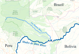
| Description | This is a map taken from https://www.openstreetmap.org/export#map=8/-11.795/-70.291, and edited to highlight the Las Piedras River, one of its tributaries, and where it drains to. |
| Source | https://www.openstreetmap.org/export#map=8/-11.795/-70.291 |
| Author | OpenStreetMap |
| Permission (Reusing this file) |
https://www.openstreetmap.org/copyright |
- Other information
English: Map was downloaded from openstreetmap.org and edited to highlight the Las Piedras River.
Licensing[edit]
This file is licensed under the Creative Commons Attribution-Share Alike 4.0 International license.
- You are free:
- to share – to copy, distribute and transmit the work
- to remix – to adapt the work
- Under the following conditions:
- attribution – You must give appropriate credit, provide a link to the license, and indicate if changes were made. You may do so in any reasonable manner, but not in any way that suggests the licensor endorses you or your use.
- share alike – If you remix, transform, or build upon the material, you must distribute your contributions under the same or compatible license as the original.
File history
Click on a date/time to view the file as it appeared at that time.
| Date/Time | Thumbnail | Dimensions | User | Comment | |
|---|---|---|---|---|---|
| current | 03:14, 7 April 2018 | | 942 × 649 (374 KB) | UliHeiral (talk | contribs) | Brighter version of map |
| 03:06, 7 April 2018 |  | 942 × 649 (378 KB) | UliHeiral (talk | contribs) | {{subst:Upload marker added by en.wp UW}} {{Information |Description = {{en|This is a map taken from https://www.openstreetmap.org/export#map=8/-11.795/-70.291, and edited to highlight the Las Piedras River, one of its tributaries, and where it drains to.}} |Source = https://www.openstreetmap.org/export#map=8/-11.795/-70.291 |Author = OpenStreetMap |Permission = https://www.openstreetmap.org/copyright }} ;Other information: {{en|Map was downloaded from openstreetmap.org and edited to highlig... |
You cannot overwrite this file.
File usage on Commons
There are no pages that use this file.
File usage on other wikis
The following other wikis use this file:
- Usage on en.wikipedia.org