File:Map of Indiana highlighting Floyd County.svg
Jump to navigation
Jump to search

Size of this PNG preview of this SVG file: 391 × 599 pixels. Other resolutions: 156 × 240 pixels | 313 × 480 pixels | 501 × 768 pixels | 668 × 1,024 pixels | 1,337 × 2,048 pixels | 2,887 × 4,423 pixels.
Original file (SVG file, nominally 2,887 × 4,423 pixels, file size: 56 KB)
Captions
Captions
Add a one-line explanation of what this file represents
Summary[edit]
| Description |
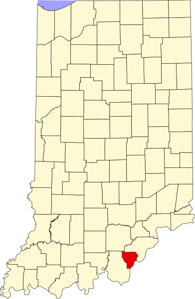
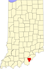
English: This is a locator map showing Floyd County in Indiana. For more information, see Commons:United States county locator maps. |
| Date | |
| Source |
Own work: English: The maps use data from nationalatlas.gov, specifically countyp020.tar.gz on the Raw Data Download page. The maps also use state outline data from statesp020.tar.gz. The Florida maps use hydrogm020.tar.gz to display Lake Okeechobee. |
| Author | David Benbennick |
Licensing[edit]
| I, the copyright holder of this work, release this work into the public domain. This applies worldwide. In some countries this may not be legally possible; if so: I grant anyone the right to use this work for any purpose, without any conditions, unless such conditions are required by law. |
File history
Click on a date/time to view the file as it appeared at that time.
| Date/Time | Thumbnail | Dimensions | User | Comment | |
|---|---|---|---|---|---|
| current | 12:10, 12 February 2006 | | 2,887 × 4,423 (56 KB) | David Benbennick (talk | contribs) | {{subst:User:Dbenbenn/clm|county=Floyd County|state=Indiana}} |
You cannot overwrite this file.
File usage on Commons
The following 16 pages use this file:
- Category:Agriculture in Floyd County, Indiana
- Category:Art of Floyd County, Indiana
- Category:Bodies of water in Floyd County, Indiana
- Category:Bridges in Floyd County, Indiana
- Category:Education in Floyd County, Indiana
- Category:Floyd County, Indiana
- Category:Geography of Floyd County, Indiana
- Category:Historic districts in Floyd County, Indiana
- Category:Maps of Floyd County, Indiana
- Category:National Register of Historic Places in Floyd County, Indiana
- Category:People of Floyd County, Indiana
- Category:Populated places in Floyd County, Indiana
- Category:Rivers of Floyd County, Indiana
- Category:Structures in Floyd County, Indiana
- Category:Towns in Floyd County, Indiana
- Category:Visitor attractions in Floyd County, Indiana
File usage on other wikis
The following other wikis use this file:
- Usage on ar.wikipedia.org
- Usage on azb.wikipedia.org
- Usage on bg.wikipedia.org
- Usage on bpy.wikipedia.org
- Usage on cdo.wikipedia.org
- Usage on ceb.wikipedia.org
- Usage on ce.wikipedia.org
- Usage on cy.wikipedia.org
- Usage on de.wikipedia.org
- Usage on en.wikipedia.org
- List of counties in Indiana
- Floyd County, Indiana
- Galena, Indiana
- Georgetown, Floyd County, Indiana
- Greenville, Indiana
- New Albany, Indiana
- Floyds Knobs, Indiana
- Mount St. Francis, Indiana
- New Albany Downtown Historic District (Indiana)
- East Spring Street Historic District
- Edwardsville, Indiana
- Template:Floyd County, Indiana
- Franklin Township, Floyd County, Indiana
- Georgetown Township, Floyd County, Indiana
- Greenville Township, Floyd County, Indiana
- Lafayette Township, Floyd County, Indiana
- New Albany Township, Floyd County, Indiana
- Template:FloydCountyIN-geo-stub
- Navilleton, Indiana
- Saint Joseph, Floyd County, Indiana
- Saint Marys, Floyd County, Indiana
- Scottsville, Indiana
- Duncan, Indiana
- User:Nyttend/County templates/IN/1
- Blackiston Mill, Indiana
- National Register of Historic Places listings in Floyd County, Indiana
- Category:Populated places in Floyd County, Indiana
- List of Indiana state historical markers in Floyd County
- Silver Hills, Indiana
- Buchanan, Indiana
- User:Br.gamache/sandbox
- Hedden's Grove Historic District
- Georgetown Historic District (Georgetown, Indiana)
- Usage on es.wikipedia.org
View more global usage of this file.