File:Map of Florida roads NA nomenu.gif
Jump to navigation
Jump to search
No higher resolution available.
Map_of_Florida_roads_NA_nomenu.gif (595 × 560 pixels, file size: 70 KB, MIME type: image/gif)
Captions
Captions
Add a one-line explanation of what this file represents
Summary[edit]
| Description |
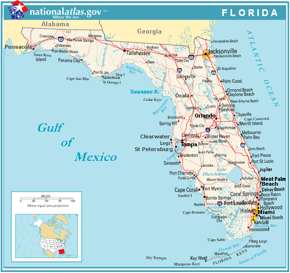
Road map of Florida, with major roads, from the U.S. Government National Atlas (trimmed/edited to bold names of Florida, Georgia, Alabama, "Gulf of Mexico" and major cities). The left-side legend menu is not displayed. The file is in GIF format, 9x faster than the large PNG format, displaying up to 30 seconds faster than the PNG-format file, but also with clear colors. The file is intended for use in frequently-read articles, where faster image display affects many users. |
| Date | |
| Source | U.S. National Atlas website. |
| Author | Wikid77, editing U.S. National Atlas map. |
| Other versions |
Old variation showing left-side legend menu: Same map, showing left-side legend menu: |
Licensing[edit]
This map was obtained from an edition of the National Atlas of the United States. Like almost all works of the U.S. federal government, works from the National Atlas are in the public domain in the United States.
Online access: NationalAtlas.gov | 1970 print edition: Library of Congress, Perry-Castañeda Library
|
File history
Click on a date/time to view the file as it appeared at that time.
| Date/Time | Thumbnail | Dimensions | User | Comment | |
|---|---|---|---|---|---|
| current | 07:19, 5 March 2009 | | 595 × 560 (70 KB) | Wikid77 (talk | contribs) | {{Information |Description=initial upload |Source=Own work by uploader |Author=Wikid77 |Date=05-March-2009 |Permission={{PD-USGov-Atlas}} |other_versions= }} <!--{{ImageUpload|full}}--> |
You cannot overwrite this file.
File usage on Commons
The following page uses this file: