File:Map of Ferrocarril Durango–Zumárraga .svg
Jump to navigation
Jump to search

Size of this PNG preview of this SVG file: 800 × 454 pixels. Other resolutions: 320 × 181 pixels | 640 × 363 pixels | 1,024 × 581 pixels | 1,280 × 726 pixels | 2,560 × 1,452 pixels | 1,169 × 663 pixels.
Original file (SVG file, nominally 1,169 × 663 pixels, file size: 763 KB)
Captions
Captions
Add a one-line explanation of what this file represents
Summary[edit]
| Description |
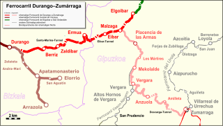
Español: Mapa del Ferrocarril Durango–Zumárraga |
| Date | |
| Source |
Map was created by using
|
| Author |
|
| Permission (Reusing this file) |
Map data (c) OpenStreetMap (and) contributors, CC-BY-SA |
Licensing[edit]
I, the copyright holder of this work, hereby publish it under the following license:
This file is licensed under the Creative Commons Attribution 3.0 Unported license.
Attribution: Peter Christener
- You are free:
- to share – to copy, distribute and transmit the work
- to remix – to adapt the work
- Under the following conditions:
- attribution – You must give appropriate credit, provide a link to the license, and indicate if changes were made. You may do so in any reasonable manner, but not in any way that suggests the licensor endorses you or your use.
| This work is licensed under the Open Database License (summary). |
File history
Click on a date/time to view the file as it appeared at that time.
| Date/Time | Thumbnail | Dimensions | User | Comment | |
|---|---|---|---|---|---|
| current | 16:19, 11 June 2017 | | 1,169 × 663 (763 KB) | Pechristener (talk | contribs) | Branch to Elorrio added |
| 10:20, 4 June 2017 |  | 1,169 × 663 (686 KB) | Pechristener (talk | contribs) | some issues with the frame solved | |
| 10:19, 4 June 2017 |  | 1,075 × 650 (669 KB) | Pechristener (talk | contribs) | == {{int:filedesc}} == {{Information |Description ={{es|1=Mapa del {{w|Ferrocarriles Vascongados|Ferrocarril Durango–Zumárraga|es}}}} |Source =Map was created by using * [http://www.openstreetmap.org/ Open Street Map] Data |Author... |
You cannot overwrite this file.
File usage on Commons
There are no pages that use this file.
File usage on other wikis
The following other wikis use this file:
- Usage on de.wikipedia.org