File:Map of Europe 2007 (political) de.png
Jump to navigation
Jump to search

Size of this preview: 800 × 523 pixels. Other resolutions: 320 × 209 pixels | 640 × 418 pixels | 1,024 × 669 pixels | 1,280 × 836 pixels | 1,596 × 1,043 pixels.
Original file (1,596 × 1,043 pixels, file size: 109 KB, MIME type: image/png)
Captions
Captions
Add a one-line explanation of what this file represents
Summary[edit]
| Description |
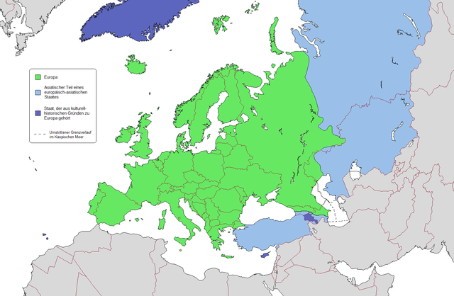
Deutsch: Geografische und politische Grenzen Europas (2007)
English: Geographical and political boundaries of Europe (2007). Note that the Caucasus watershed is not indicated correctly, it runs along Georgia's northern border. |
| Date | (UTC) |
| Source | |
| Author |
|
| Other versions |
|


_de.png)
.png)


_de.png&action=edit§ion=1)
Licensing[edit]
_de.png&action=edit§ion=2)
I, the copyright holder of this work, hereby publish it under the following license:
This file is licensed under the Creative Commons Attribution 3.0 Unported license.
- You are free:
- to share – to copy, distribute and transmit the work
- to remix – to adapt the work
- Under the following conditions:
- attribution – You must give appropriate credit, provide a link to the license, and indicate if changes were made. You may do so in any reasonable manner, but not in any way that suggests the licensor endorses you or your use.
Original upload log[edit]
_de.png&action=edit§ion=3)
This image is a derivative work of the following images:
- File:Map_of_Europe_(political).png licensed with GFDL
- 2009-02-03T09:46:18Z Koyos 1596x1043 (110005 Bytes) reverting geographically inaccurate color coding
- 2008-07-18T13:16:24Z Aegean Boy 1596x1043 (110096 Bytes) {{Information |Description= |Source= |Date= |Author= |Permission= |other_versions= }}
- 2008-06-20T15:03:21Z Westermarck 1596x1043 (110005 Bytes) {{Information |Description= |Source= |Date= |Author= |Permission= |other_versions= }}
- 2007-01-15T21:02:56Z Jon Harald Søby 1596x1043 (110089 Bytes) small change in Azerbaijan's colour
- 2006-12-03T14:06:17Z Electionworld 1596x1043 (117601 Bytes) {[ew|en|Alinor}} According to [[Transcontinental nation|one common view]] of the boundary, the European continent is the area coloured green on this map. The light blue/dark blue colors are described at [[Transcontinental nat
Uploaded with derivativeFX
File history
Click on a date/time to view the file as it appeared at that time.
| Date/Time | Thumbnail | Dimensions | User | Comment | |
|---|---|---|---|---|---|
| current | 23:21, 15 November 2009 | | 1,596 × 1,043 (109 KB) | Kolja21 (talk | contribs) | Abgleich mit engl. Fassung, s. Diskussionsseite |
| 02:41, 19 February 2009 |  | 1,596 × 1,043 (110 KB) | Kolja21 (talk | contribs) | == Summary == {{Information |Description= {{en|1=Political geography of Europe (2007)}} {{de|1=Geografische und politische Grenzen Europas (2007)}} |Source=*File:Map_of_Europe_(political).png |Date=2009-02-19 02:37 (UTC) |Author=*[[:File:Map_of_Euro |
You cannot overwrite this file.
File usage on Commons
The following 5 pages use this file:
File usage on other wikis
The following other wikis use this file:
_de.png&oldid=753997456)