File:Map of Europe (political).png
Original file (1,596 × 1,043 pixels, file size: 86 KB, MIME type: image/png)
Captions
Captions

|
This map has been uploaded by Electionworld from en.wikipedia.org to enable the |
Summary[edit]
.png&action=edit§ion=1)
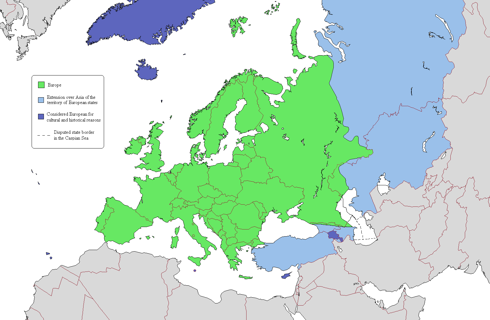
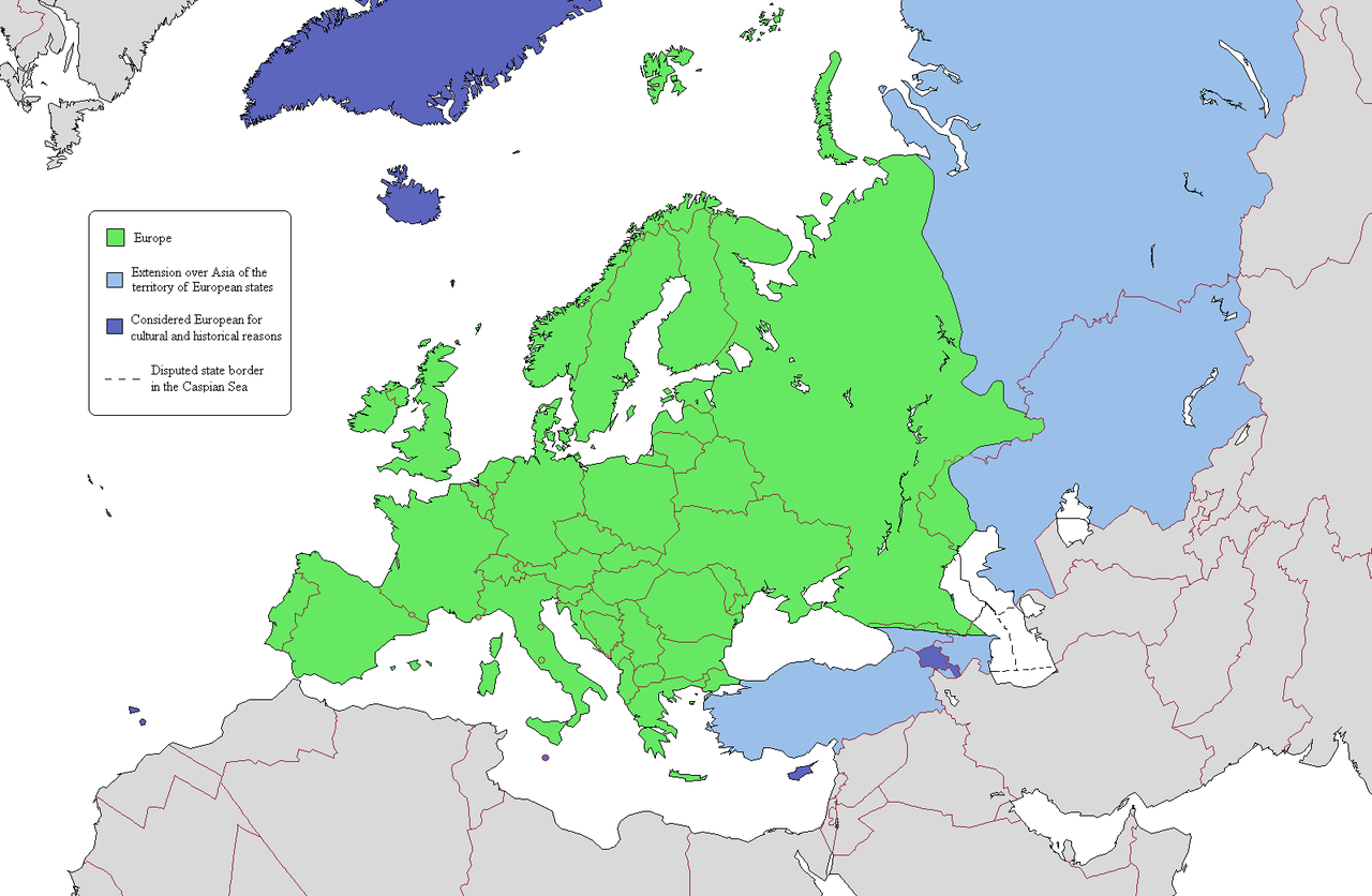
This is a map intended to show the continental boundary of Europe, and the territory of transcontinental states. The map is flawed in a number of ways, and a corrected version is found at [[: File:Europe Asia transcontinental.png]]. Since the latter is a derived version of this one, a copy of the flawed map should be kept around for licencing reasons. The original map appears to have been uploaded to Wikipedia in 2006 by en:User:Alinor.
Derivative works of this file: Europe Asia transcontinental.png
Derivative works of this file: Map of Europe 2007 (political) de.png
_de.png)

|
This map image could be re-created using vector graphics as an SVG file. This has several advantages; see Commons:Media for cleanup for more information. If an SVG form of this image is available, please upload it and afterwards replace this template with
{{vector version available|new image name}}.
It is recommended to name the SVG file “Map of Europe (political).svg”—then the template Vector version available (or Vva) does not need the new image name parameter. |
Licensing[edit]
.png&action=edit§ion=2)

|
Permission is granted to copy, distribute and/or modify this document under the terms of the GNU Free Documentation License, Version 1.2 or any later version published by the Free Software Foundation; with no Invariant Sections, no Front-Cover Texts, and no Back-Cover Texts. A copy of the license is included in the section entitled GNU Free Documentation License. |
| This file is licensed under the Creative Commons Attribution-Share Alike 3.0 Unported license. | ||
| ||
| This licensing tag was added to this file as part of the GFDL licensing update. |
File history
Click on a date/time to view the file as it appeared at that time.
.png&dir=prev)
.png&offset=20110409134150)
.png&offset=&limit=20)
.png&offset=&limit=50)
.png&offset=&limit=100)
.png&offset=&limit=250)
.png&offset=&limit=500)
| Date/Time | Thumbnail | Dimensions | User | Comment | |
|---|---|---|---|---|---|
| current | 22:03, 20 June 2019 | | 1,596 × 1,043 (86 KB) | Rs4815 (talk | contribs) | Border in the south-east passes along the Greater Caucasus Range |
| 04:05, 16 April 2011 |  | 1,596 × 1,043 (107 KB) | Wsiegmund (talk | contribs) | Reverted to version as of 19:16, 13 November 2009; see http://commons.wikimedia.org/w/index.php?title=User_talk:Wsiegmund&oldid=53219388#File:Map_of_Europe_.28political.29.png | |
| 03:28, 13 April 2011 |  | 1,596 × 1,043 (71 KB) | Green, White and Gold (talk | contribs) | Reverted to Dbachmann's version as of 11:49, 8 April 2011 | |
| 02:37, 13 April 2011 |  | 1,596 × 1,043 (71 KB) | Gerge (talk | contribs) | Reverted to version as of 06:06, 12 April 2011 | |
| 23:12, 12 April 2011 |  | 1,596 × 1,043 (71 KB) | Green, White and Gold (talk | contribs) | Reverted to Dbachmann's version as of 11:49, 8 April 2011 | |
| 23:09, 12 April 2011 |  | 1,596 × 1,043 (107 KB) | Green, White and Gold (talk | contribs) | Reverted to Dbachmann's version as of 13:41, 9 April 2011 | |
| 06:06, 12 April 2011 |  | 1,596 × 1,043 (71 KB) | Sigismun (talk | contribs) | Reverted to version as of 19:54, 10 April 2011 | |
| 01:06, 12 April 2011 |  | 1,596 × 1,043 (107 KB) | Green, White and Gold (talk | contribs) | Reverted to Dbachmann's version as of 13:41, 9 April 2011 | |
| 19:54, 10 April 2011 |  | 1,596 × 1,043 (71 KB) | ComtesseDeMingrelie (talk | contribs) | rv. per Commons:Avoid overwriting existing files | |
| 13:41, 9 April 2011 |  | 1,596 × 1,043 (107 KB) | Dbachmann (talk | contribs) | so, since this map is going to be useless anyway, rv to 3 February 2009 per "Commons:Avoid overwriting existing files." |
You cannot overwrite this file.
File usage on Commons
The following 7 pages use this file:
File usage on other wikis
The following other wikis use this file:
- Usage on cs.wikipedia.org
- Usage on da.wikipedia.org
- Usage on de.wikipedia.org
- Usage on en.wikipedia.org
- User:Rashed
- User:Siyavash
- User:Kenzilla
- User:Australian Jezza
- Template:User Eurasian
- User:WiKID Daryl
- User:Royaljared
- User:Angelo De La Paz
- User:PinkPanthress
- Talk:Georgia/Archive 1
- User:Finlandlover
- User talk:BadYodels
- User:Tweisbach
- User:Obaidz96/UBX
- User:Czar Choi
- User:Lenoxus/Subpages/Public/Old
- User:Masumisyan
- User:PKLion
- User:Sweet & Sour Grapes
- User:Shakarian141
- User:Niceguy90
- User:Epileptic Mushroom
- Talk:Armenia/Archive 5
- User:Alexander Rudik
- User:Kunayev
- User:Bush111
- Wikipedia:Graphics Lab/Map workshop/Archive/Apr 2010
- Template talk:Passports/Archive 1
- User:Bgh1111
- User:Lukex115
- User:Lukex115/Userboxen
- User:RussLover
- User:Jextredo
- User:Azndrumsticks
- User:Katangais/Travel
- Wikipedia:Userboxes/Life/Ethnicity
- User:Slawful Justice
- User:Weidorje
- User:Alfredcranham
- User:Chinggis6/Tengerid Traits
- Usage on es.wikipedia.org
- Usage on fr.wikipedia.org
- Usage on it.wikipedia.org
- Usage on ko.wikipedia.org
- Usage on mk.wikipedia.org
- Usage on pl.wikipedia.org
View more global usage of this file.
.png)
.png&oldid=753997448)