File:Map of Carlsbad Caverns National Park.png
From Wikimedia Commons, the free media repository
Jump to navigation
Jump to search

Size of this preview: 705 × 600 pixels. Other resolutions: 282 × 240 pixels | 564 × 480 pixels | 903 × 768 pixels | 1,204 × 1,024 pixels | 2,408 × 2,048 pixels | 3,121 × 2,655 pixels.
Original file (3,121 × 2,655 pixels, file size: 704 KB, MIME type: image/png)
File information
Structured data
Captions
Captions
Add a one-line explanation of what this file represents
| DescriptionMap of Carlsbad Caverns National Park.png |
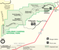
Map of Carlsbad Caverns National Park — in the Guadalupe Mountains, Eddy County, southeastern New Mexico.
|
||
| Source | http://www.nps.gov | ||
| Author | National Park Service |
| Public domainPublic domainfalsefalse |
| This image or media file contains material based on a work of a National Park Service employee, created as part of that person's official duties. As a work of the U.S. federal government, such work is in the public domain in the United States. See the NPS website and NPS copyright policy for more information. |  |
File history
Click on a date/time to view the file as it appeared at that time.
| Date/Time | Thumbnail | Dimensions | User | Comment | |
|---|---|---|---|---|---|
| current | 00:10, 26 June 2022 |  | 3,121 × 2,655 (704 KB) | Joliv (talk | contribs) | Update to current NPS version (different spellings, better rasterization, removed ranger stn) |
| 10:40, 23 March 2008 |  | 1,104 × 936 (113 KB) | Finavon (talk | contribs) | border cropped | |
| 06:00, 25 August 2006 |  | 1,145 × 945 (140 KB) | Huebi~commonswiki (talk | contribs) | {{Information |Description=Map of Carlsbad Caverns National Park |Source=http://www.nps.gov |Date= |Author= |Permission= |other_versions= }} {{PD-USGov-NPS}} category:Carlsbad Caverns National Park |
You cannot overwrite this file.
File usage on Commons
The following 2 pages use this file:
File usage on other wikis
The following other wikis use this file:
- Usage on ca.wikipedia.org
- Usage on da.wikipedia.org
- Usage on de.wikipedia.org
- Usage on en.wikipedia.org
- Usage on fa.wikipedia.org
- Usage on fr.wikipedia.org
- Usage on hr.wikipedia.org
- Usage on ko.wikipedia.org
- Usage on nl.wikipedia.org
- Usage on pl.wikipedia.org
- Usage on ro.wikipedia.org
- Usage on tr.wikipedia.org