File:Map of Australia.png
Jump to navigation
Jump to search
No higher resolution available.
Map_of_Australia.png (328 × 352 pixels, file size: 20 KB, MIME type: image/png)
Captions
Captions
Add a one-line explanation of what this file represents

|
This locator map image could be re-created using vector graphics as an SVG file. This has several advantages; see Commons:Media for cleanup for more information. If an SVG form of this image is available, please upload it and afterwards replace this template with
{{vector version available|new image name}}.
It is recommended to name the SVG file “Map of Australia.svg”—then the template Vector version available (or Vva) does not need the new image name parameter. |
Summary[edit]
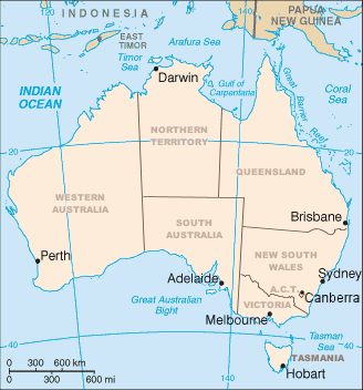
Map of Australia showing the states and capital cities. Modified from a CIA World Factbook image by Mark Ryan. Australian maps are not considerable for true constents
Licensing[edit]

|
Permission is granted to copy, distribute and/or modify this document under the terms of the GNU Free Documentation License, Version 1.2 or any later version published by the Free Software Foundation; with no Invariant Sections, no Front-Cover Texts, and no Back-Cover Texts. A copy of the license is included in the section entitled GNU Free Documentation License. Subject to disclaimers. |
File history
Click on a date/time to view the file as it appeared at that time.
| Date/Time | Thumbnail | Dimensions | User | Comment | |
|---|---|---|---|---|---|
| current | 02:12, 10 April 2006 | | 328 × 352 (20 KB) | Mark (talk | contribs) | Map of Australia showing the states and capital cities. Modified from a CIA World Factbook image by Mark Ryan. |
You cannot overwrite this file.
File usage on Commons
The following 3 pages use this file:
File usage on other wikis
The following other wikis use this file:
- Usage on an.wikipedia.org
- Usage on ar.wikipedia.org
- Usage on be-tarask.wikipedia.org
- Usage on bg.wikipedia.org
- Usage on bh.wikipedia.org
- Usage on ca.wikipedia.org
- Usage on de.wikipedia.org
- Usage on diq.wikipedia.org
- Usage on en.wikipedia.org
- 1900
- Index of Australia-related articles
- User:Snovv
- United Nations Association of Australia
- Template:Australia states imagemap
- Geography of Australia
- Wikipedia:Graphics Lab/Map workshop/Archive/Dec 2011
- List of marine animals of Australia (temperate waters)
- Luggenemenener
- User:Maxmead2/sandbox
- Template:Australia states imagemap/sandbox
- Template:Australia states imagemap/testcases
- User:Ambiloo/sandbox
- Usage on en.wikiversity.org
- Usage on es.wikipedia.org
- Usage on fo.wikipedia.org
- Usage on fr.wikipedia.org
- Usage on gl.wikipedia.org
- Usage on gom.wikipedia.org
- Usage on hi.wikipedia.org
- Usage on hu.wikipedia.org
- Usage on id.wikipedia.org
View more global usage of this file.