File:Map of Aircraft Locations in Cuba - DPLA - 8fc2cd609283985218cbbdd025baa17e.jpg
Jump to navigation
Jump to search

Size of this preview: 800 × 540 pixels. Other resolutions: 320 × 216 pixels | 640 × 432 pixels | 1,024 × 691 pixels | 1,200 × 810 pixels.
Original file (1,200 × 810 pixels, file size: 138 KB, MIME type: image/jpeg)
Captions
Captions
Add a one-line explanation of what this file represents
Summary[edit]
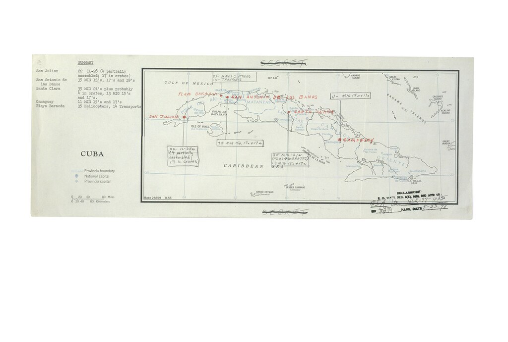
| Map of Aircraft Locations in Cuba
( |
|||||||||||||||||
|---|---|---|---|---|---|---|---|---|---|---|---|---|---|---|---|---|---|
| Creator | Sorensen, Theodore Chaikin, 1928-2010 | ||||||||||||||||
| Title |
Map of Aircraft Locations in Cuba |
||||||||||||||||
| Description |
This map was used in President John F. Kennedy's Cuban Missile Crisis meetings, standing committee, September 1962 to October 1962 to show aircraft locations in Cuba. |
||||||||||||||||
| Date | 1962-01-01/1962-12-31 | ||||||||||||||||
| Collection |
|
||||||||||||||||
| Source/Photographer |
|
||||||||||||||||
| Permission (Reusing this file) |
|
||||||||||||||||
| Standardized rights statement |
|
||||||||||||||||


File history
Click on a date/time to view the file as it appeared at that time.
| Date/Time | Thumbnail | Dimensions | User | Comment | |
|---|---|---|---|---|---|
| current | 18:04, 9 November 2022 | | 1,200 × 810 (138 KB) | DPLA bot (talk | contribs) | Uploading DPLA ID 8fc2cd609283985218cbbdd025baa17e |
You cannot overwrite this file.
File usage on Commons
The following page uses this file: