File:Map of 2. Judicial District, Alaska (1909-1921).png
Jump to navigation
Jump to search

Size of this preview: 800 × 507 pixels. Other resolutions: 320 × 203 pixels | 640 × 406 pixels | 1,024 × 649 pixels | 1,280 × 812 pixels | 2,000 × 1,268 pixels.
Original file (2,000 × 1,268 pixels, file size: 97 KB, MIME type: image/png)
Captions
Captions
Add a one-line explanation of what this file represents
Summary[edit]
.png&action=edit§ion=1)
| Description |
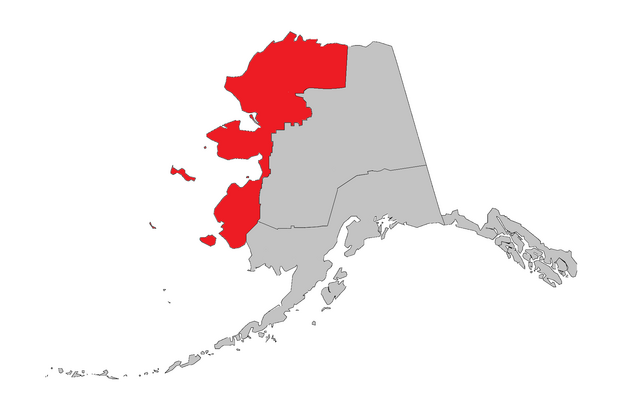
English: A map of the Second Judicial District (also refered to as Division #2) in red. Based on "Map of boroughs and census areas" av cmrivers. |
| Date | |
| Source | Own work |
| Author | TorbjørnS |
Second Judicial District was established June 6. 1900. Judicial and statistical unit. Censuses 1910-1950. Map depicts borders after a big change in border-lines in 1909 untill an adjustment in 1921.
Licensing[edit]
.png&action=edit§ion=2)
I, the copyright holder of this work, hereby publish it under the following license:
This file is licensed under the Creative Commons Attribution-Share Alike 4.0 International license.
- You are free:
- to share – to copy, distribute and transmit the work
- to remix – to adapt the work
- Under the following conditions:
- attribution – You must give appropriate credit, provide a link to the license, and indicate if changes were made. You may do so in any reasonable manner, but not in any way that suggests the licensor endorses you or your use.
- share alike – If you remix, transform, or build upon the material, you must distribute your contributions under the same or compatible license as the original.
File history
Click on a date/time to view the file as it appeared at that time.
| Date/Time | Thumbnail | Dimensions | User | Comment | |
|---|---|---|---|---|---|
| current | 02:48, 13 September 2014 | | 2,000 × 1,268 (97 KB) | TorbjørnS (talk | contribs) | User created page with UploadWizard |
You cannot overwrite this file.
File usage on Commons
There are no pages that use this file.
File usage on other wikis
The following other wikis use this file:
- Usage on no.wikipedia.org
.png&oldid=491521977)