File:Map World Cup appearances 2014 (enwiki).png

Original file (1,480 × 628 pixels, file size: 55 KB, MIME type: image/png)
Captions
Captions
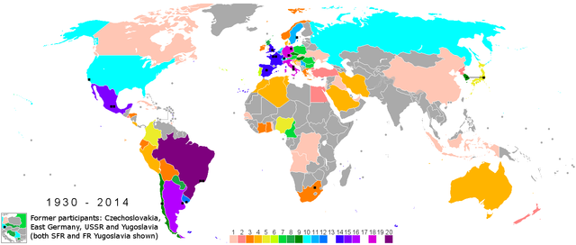
| Description | Map_World_Cup_appearances (1930-2014) |
| Date | |
| Source | Own work |
| Author | Dufo |
Image from German wikipedia
The map shows the number of final round participation of the respective countries with the FIFA world championship (colors indicated as down) and the host countries (black squares).
19 = no country
17 = no country
13 = no country
The small diagram shows the former countries USSR, Yugoslavia, Czechoslovakia and GDR.
Alternative map[edit]
.png&action=edit§ion=1)
- Only World Cups from 1930 to 2010
- Nur Weltmeisterschaften von 1930 bis 2010
File:World_cup_appearances_2010.png

File:Map World Cup appearances (enwiki).png
.png)
- All World Cups from 1930 to 2014
- Alle Weltmeisterschaften von 1930 bis 2014
File:World_cup_appearances_2014.png

| This work has been released into the public domain by its author, Dufo. This applies worldwide. In some countries this may not be legally possible; if so: |
.png)
.png)
| Annotations | This image is annotated: View the annotations at Commons |
.png)
File history
Click on a date/time to view the file as it appeared at that time.
| Date/Time | Thumbnail | Dimensions | User | Comment | |
|---|---|---|---|---|---|
| current | 20:04, 21 March 2014 | | 1,480 × 628 (55 KB) | Terek (talk | contribs) | UN recognize Crimea as part of Ukraine |
| 02:29, 20 March 2014 |  | 1,480 × 628 (59 KB) | WikiAnthony (talk | contribs) | Removed line | |
| 03:02, 17 March 2014 |  | 1,480 × 628 (59 KB) | WikiAnthony (talk | contribs) | Added Crimea | |
| 20:18, 15 January 2014 |  | 1,480 × 628 (55 KB) | WikiAnthony (talk | contribs) | French Guyana in gray | |
| 20:05, 15 January 2014 |  | 1,480 × 628 (55 KB) | WikiAnthony (talk | contribs) | Lesoto border in white | |
| 12:21, 25 November 2013 |  | 1,480 × 628 (54 KB) | Dufo (talk | contribs) | . | |
| 07:30, 21 November 2013 |  | 1,480 × 628 (54 KB) | Dufo (talk | contribs) | Border South Sudan | |
| 03:42, 21 November 2013 |  | 1,480 × 628 (54 KB) | Dufo (talk | contribs) | {{Information |Description=Map_World_Cup_appearances (1930-2014) |Source={{own}} |Date=2013-11-21 |Author=Dufo |Permission= |other_versions= }} |
You cannot overwrite this file.
File usage on Commons
The following 4 pages use this file:
File usage on other wikis
The following other wikis use this file:
- Usage on az.wikipedia.org
.png&oldid=653834787)