File:Map Showing Buildings Along Waterfront Between Marion Street & Yesler Avenue, Seattle, circa 1895 (MOHAI 13316).jpg

Original file (1,200 × 783 pixels, file size: 103 KB, MIME type: image/jpeg)
Captions
Captions
Summary[edit]
.jpg&action=edit§ion=1)
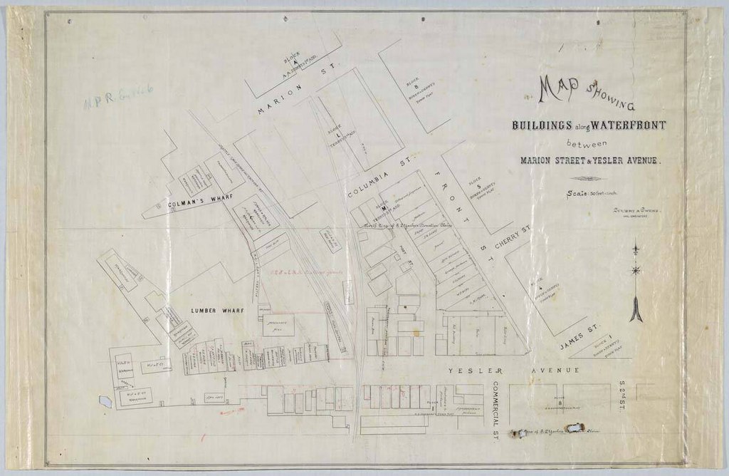
| English: Map Showing Buildings Along Waterfront Between Marion Street & Yesler Avenue, Seattle, circa 1895
( |
||||||||||||||||||||||||
|---|---|---|---|---|---|---|---|---|---|---|---|---|---|---|---|---|---|---|---|---|---|---|---|---|
| Photographer |
English: Scurry & Owens |
|||||||||||||||||||||||
| Title |
English: Map Showing Buildings Along Waterfront Between Marion Street & Yesler Avenue, Seattle, circa 1895 |
|||||||||||||||||||||||
| Description |
English: Seattle in the late nineteenth century was a rapidly growing city, aided in no small part by the 1883 connection with the Northern Pacific Railway Company (NPRR). In 1890 the city's population doubled from the previous year to 40,000, boosted by the influx of people who saw opportunity in rebuilding after Seattle's Great Fire. Expansion led to conflicts over the legal definitions of property and in what ways and by whom real estate could be utilized. NPRR was part of many lawsuits in Seattle during the period between 1895 and 1925, many of which were to establish rights-of-way and valuation of properties. The plat map pictured here, roughly of Seattle's Pioneer Square neighborhood, was used as evidence in litigation between NPRR and a member of the Denny family, probably over usage of tide lands. The map was created by Scurry & Owens, a civil engineering firm run by John G. Scurry and Henry K. Owens, that, according to the 1890 city directory, was located at 461 Seattle block (building). The map itself is undated, but each of the buildings on the map is identified by owner or function, making it possible to determine an approximate date. Stamped on verso, with handwritten notations: 23429-23430 Equity Department, N. P. Ry Co. Defendant's Exhibit #6 Caption information source: NORTHERN PACIFIC RAILWAY COMPANY. LAW DEPARTMENT: An Inventory of Its Records at the Minnesota Historical Society, Manuscripts Collection, retrieved from http://www2.mnhs.org/library/findaids/01021.xml Caption information source: Klingle, M. (2007). Emerald City: An environmental history of Seattle. New Haven, CT: Yale University Press.
Most of this is illegible at the present resolution. |
|||||||||||||||||||||||
| Depicted place |
English: United States--Washington (State)--Seattle |
|||||||||||||||||||||||
| Date | circa 1895 | |||||||||||||||||||||||
| Medium |
English: 1 map: color |
|||||||||||||||||||||||
| Dimensions | height: 36.5 in (92.7 cm); width: 23.6 in (59.9 cm) | |||||||||||||||||||||||
| Collection |
|
|||||||||||||||||||||||
| Current location | ||||||||||||||||||||||||
| Accession number | ||||||||||||||||||||||||
| Source |
English: Museum of History and Industry |
|||||||||||||||||||||||
| Permission (Reusing this file) |
|
|||||||||||||||||||||||
| Credit Line | MOHAI, 2019.3.9 | |||||||||||||||||||||||
File history
Click on a date/time to view the file as it appeared at that time.
| Date/Time | Thumbnail | Dimensions | User | Comment | |
|---|---|---|---|---|---|
| current | 20:54, 27 November 2020 | | 1,200 × 783 (103 KB) | BMacZeroBot (talk | contribs) | Batch upload (Commons:Batch uploading/University of Washington Digital Collections) |
You cannot overwrite this file.
File usage on Commons
The following page uses this file:
.jpg)
.jpg&oldid=611313035)