File:Map Greece expansion 1832-1947-eus.svg
Jump to navigation
Jump to search

Size of this PNG preview of this SVG file: 456 × 599 pixels. Other resolutions: 183 × 240 pixels | 365 × 480 pixels | 584 × 768 pixels | 779 × 1,024 pixels | 1,559 × 2,048 pixels | 730 × 959 pixels.
Original file (SVG file, nominally 730 × 959 pixels, file size: 110 KB)
Captions
Captions
Add a one-line explanation of what this file represents
Summary[edit]
| Description |
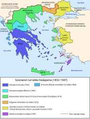
Čeština: Mapa zobrazuje územní expanzi Řeckého království (1832–1947). Dansk: Kort over Grækenlands territoriale udvidelser, 1832-1947. Deutsch: Territoriale Expansion Griechenlands 1832-1947. English: The territorial expansion of Greece, 1832-1947. Español: Mapa de la expansión territorial griega (1832-1947) Euskara: Greziaren lurralde hedapena 1832-1947 bitartean Français : L'expansion territoriale de la Grèce. 1832-1947. Hrvatski: Teritorijalno proširenje Grčke u razdoblju od 1832. do 1947. Italiano: L'espansione territoriale della Grecia dal 1832 al 1947 Magyar: Görögország területi növekedése (1832-1947) Occitan : Evolucions territòrialas de Grècia. Ελληνικά: Η εδαφική επέκταση της Ελλάδας 1832-1947. Македонски: Територијално проширување на Грција Українська: Територіальна експансія Греції (1832-1947). 日本語: ギリシャ王国の版図拡大 (1832-1947年) 中文: 希腊的领土变迁,1832年-1947年间。 العربية : خريطة تُصوِّر الأراضي التي استولت عليها اليونان مُنذُ سنة 1832م حين استقلالها عن الدولة العُثمانيَّة، وُصولًا إلى سنة 1947م |
||
| Date | |||
| Source |
 |
||
| Author | User:Historicair |
Licensing[edit]
This file is licensed under the Creative Commons Attribution-Share Alike 3.0 Unported license.
- You are free:
- to share – to copy, distribute and transmit the work
- to remix – to adapt the work
- Under the following conditions:
- attribution – You must give appropriate credit, provide a link to the license, and indicate if changes were made. You may do so in any reasonable manner, but not in any way that suggests the licensor endorses you or your use.
- share alike – If you remix, transform, or build upon the material, you must distribute your contributions under the same or compatible license as the original.
File history
Click on a date/time to view the file as it appeared at that time.
| Date/Time | Thumbnail | Dimensions | User | Comment | |
|---|---|---|---|---|---|
| current | 10:58, 4 August 2021 | | 730 × 959 (110 KB) | Sikret8 (talk | contribs) | Letra mota |
| 10:56, 4 August 2021 |  | 730 × 959 (61 KB) | Sikret8 (talk | contribs) | Letra mota | |
| 10:51, 4 August 2021 |  | 730 × 959 (106 KB) | Sikret8 (talk | contribs) | Uploaded a work by User:Historicair from File:Map_Greece_expansion_1832-1947-en.svg with UploadWizard |
You cannot overwrite this file.
File usage on Commons
The following 31 pages use this file:
- User:Magog the Ogre/Multilingual legend/2021 August 1-10
- File:ExpansionofModernGreece.png
- File:Greek history from 1832-ar.png
- File:Greek history from 1832.GIF
- File:Greekhistory-zh-classical.png
- File:Greekhistory el.gif
- File:Grècia - Evolucions territòrialas.png
- File:La expansión territorial de Grecia (1832-1947).PNG
- File:Map Greece Megali Idea (hy).png
- File:Map Greece expansion 1832-1947-HE.svg
- File:Map Greece expansion 1832-1947-ar.svg
- File:Map Greece expansion 1832-1947-cs-2.svg
- File:Map Greece expansion 1832-1947-da.svg
- File:Map Greece expansion 1832-1947-el.svg
- File:Map Greece expansion 1832-1947-en.svg
- File:Map Greece expansion 1832-1947-es.svg
- File:Map Greece expansion 1832-1947-eu.png
- File:Map Greece expansion 1832-1947-fr.svg
- File:Map Greece expansion 1832-1947-he.svg
- File:Map Greece expansion 1832-1947-hr.svg
- File:Map Greece expansion 1832-1947-hu.svg
- File:Map Greece expansion 1832-1947-it.svg
- File:Map Greece expansion 1832-1947-mk.svg
- File:Map Greece expansion 1832-1947-nl.svg
- File:Map Greece expansion 1832-1947-sr.svg
- File:Map Greece expansion 1832-1947-zhcn.svg
- File:Map Greece expansion 1832-1947 ja.svg
- File:Territorial Expansion of Greece from 1832–1947.gif
- File:Επέκταση Ελλάδας 1832-1947.svg
- File:Територіальна експансія Греції в 1832-1947рр.png
- Template:Other versions/Map Greece expansion 1832-1947
.PNG)
.png)