File:Map France 1180-fr.svg
Jump to navigation
Jump to search

Size of this PNG preview of this SVG file: 527 × 600 pixels. Other resolutions: 211 × 240 pixels | 422 × 480 pixels | 675 × 768 pixels | 900 × 1,024 pixels | 1,800 × 2,048 pixels | 988 × 1,124 pixels.
Original file (SVG file, nominally 988 × 1,124 pixels, file size: 1.88 MB)
Captions
Captions
Add a one-line explanation of what this file represents
Légende[edit]
Summary[edit]
| Description |
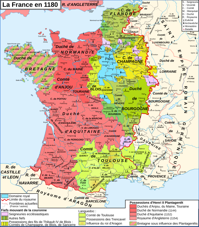
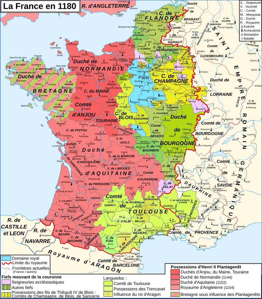
English: Map of France in 1180
Français : Carte de la France en 1180 |
| Date | |
| Source |
English: Own work, from Image:France 12thC.jpg, in William R. Shepherd, The Historical Atlas, 1911
Data from the same and:
Français : Création personnelle, d'après Image:France 12thC.jpg, in William R. Shepherd, The Historical Atlas, 1911
Données d'après cette source et :
|
| Author | Zigeuner |
| Other versions |
Derivative works of this file:
|


.png)

|
This SVG file contains embedded text that can be translated into your language, using any capable SVG editor, text editor or the SVG Translate tool. For more information see: About translating SVG files. |
Licensing[edit]
I, the copyright holder of this work, hereby publish it under the following licenses:

|
Permission is granted to copy, distribute and/or modify this document under the terms of the GNU Free Documentation License, Version 1.2 or any later version published by the Free Software Foundation; with no Invariant Sections, no Front-Cover Texts, and no Back-Cover Texts. A copy of the license is included in the section entitled GNU Free Documentation License. |
This file is licensed under the Creative Commons Attribution-Share Alike 3.0 Unported, 2.5 Generic, 2.0 Generic and 1.0 Generic license.
- You are free:
- to share – to copy, distribute and transmit the work
- to remix – to adapt the work
- Under the following conditions:
- attribution – You must give appropriate credit, provide a link to the license, and indicate if changes were made. You may do so in any reasonable manner, but not in any way that suggests the licensor endorses you or your use.
- share alike – If you remix, transform, or build upon the material, you must distribute your contributions under the same or compatible license as the original.
You may select the license of your choice.
File history
Click on a date/time to view the file as it appeared at that time.
| Date/Time | Thumbnail | Dimensions | User | Comment | |
|---|---|---|---|---|---|
| current | 11:35, 9 January 2009 | | 988 × 1,124 (1.88 MB) | ZigeunerAlt (talk | contribs) | + seigneurie de Montpensier, couleur du Velay, vicomté de Marsan |
| 15:51, 12 December 2008 |  | 988 × 1,124 (1.88 MB) | ZigeunerAlt (talk | contribs) | Retour des limites d'arrière-fiefs dans le duché d'Aquitaine | |
| 14:07, 12 December 2008 |  | 988 × 1,124 (1.88 MB) | ZigeunerAlt (talk | contribs) | + comté d'Alençon, seigneurie d'Harcourt (Normandie) | |
| 15:42, 6 December 2008 |  | 988 × 1,124 (1.88 MB) | ZigeunerAlt (talk | contribs) | Tonnerre de la même couleur que Nevers et Auxerre | |
| 22:43, 5 December 2008 |  | 988 × 1,124 (1.88 MB) | ZigeunerAlt (talk | contribs) | Couleurs identiques pour Flandres/Vermandois/Valois | |
| 15:02, 3 December 2008 |  | 988 × 1,124 (1.88 MB) | ZigeunerAlt (talk | contribs) | {{Information |Description={{en|1=Map of the France in 1180}} {{fr|1=Carte de la France en 1180}} |Source=travail personnel (own work) |Author=Zigeuner |Date=3 XII 2008 |Permission= |other_versions=Image:Map France 1030-fr.svg }} <!--{{ |
You cannot overwrite this file.
File usage on Commons
The following 10 pages use this file:
.png)
File usage on other wikis
The following other wikis use this file:
- Usage on avk.wikipedia.org
- Usage on bg.wikipedia.org
- Usage on ca.wikipedia.org
- Usage on cs.wikipedia.org
- Usage on da.wikipedia.org
- Usage on de.wikipedia.org
- Usage on el.wikipedia.org
- Usage on en.wikipedia.org
- Usage on en.wikibooks.org
- Usage on eo.wikipedia.org
- Usage on es.wikipedia.org
- Usage on et.wikipedia.org
- Usage on eu.wikipedia.org
- Usage on fr.wikipedia.org
View more global usage of this file.
Metadata
Categories:
- SVG maps of the history of France
- French-language SVG maps showing history
- Maps of 12th-century France
- Angevin Empire
- County of Champagne
- Maps of the county of Flanders
- Duchy of Burgundy
- County of Burgundy
- Duchy of Brittany
- Maps of the history of Hainaut
- Maps of the history of Brabant
- Maps of the Duchy of Lorraine
- Duchy of Normandy
- Maine (province)
- County of Anjou
- Touraine
- Duchy of Aquitaine
- Nivernais
- Bourbonnais
- Maps of Poitou
- Angoumois
- County of Auvergne
- Maps of Dauphiné
- Maps of the Duchy of Savoy
- Maps of the history of Provence
- County of Toulouse
- County of Foix
- Roussillon
- Kingdom of Navarre
- Duchy of Luxembourg
- Astarac
- Geography of Béarn
- Bigorre
- Maps of Comminges
- Maps of Aunis
- Perche