File:Map France 1030-es.svg
Jump to navigation
Jump to search

Size of this PNG preview of this SVG file: 526 × 599 pixels. Other resolutions: 211 × 240 pixels | 421 × 480 pixels | 674 × 768 pixels | 899 × 1,024 pixels | 1,799 × 2,048 pixels | 1,053 × 1,199 pixels.
Original file (SVG file, nominally 1,053 × 1,199 pixels, file size: 4.12 MB)
Captions
Captions
Add a one-line explanation of what this file represents
Summary[edit]
| Description |
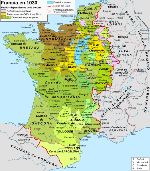
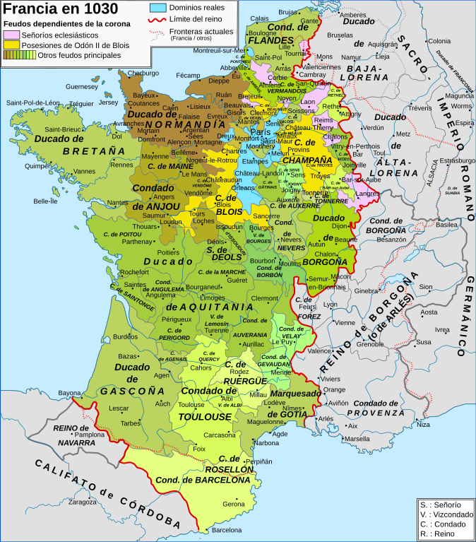
English: Map of the France in 1030 Español: Mapa de Francia en 1030 Français : Carte de la France en 1030 |
| Date | (UTC) |
| Source | |
| Author |
|
| Other versions |
[]
|


| This is a retouched picture, which means that it has been digitally altered from its original version. The original can be viewed here: Map France 1030-fr.svg:
|
I, the copyright holder of this work, hereby publish it under the following licenses:
This file is licensed under the Creative Commons Attribution-Share Alike 3.0 Unported, 2.5 Generic, 2.0 Generic and 1.0 Generic license.
- You are free:
- to share – to copy, distribute and transmit the work
- to remix – to adapt the work
- Under the following conditions:
- attribution – You must give appropriate credit, provide a link to the license, and indicate if changes were made. You may do so in any reasonable manner, but not in any way that suggests the licensor endorses you or your use.
- share alike – If you remix, transform, or build upon the material, you must distribute your contributions under the same or compatible license as the original.
You may select the license of your choice.
Original upload log[edit]
This image is a derivative work of the following images:
- File:Map_France_1030-fr.svg licensed with Cc-by-sa-3.0,2.5,2.0,1.0, Cc-by-sa-3.0,2.5,2.0,1.0
- 2008-06-18T20:16:34Z Zigeuner 988x1124 (810778 Bytes) {{Information |Description={{en|1=Map of the France in 1030}} {{fr|1=Carte de la France en 1030}} |Source=travail personnel (own work) [http://www.lib.utexas.edu/maps/historical/shepherd_1911/shepherd-c-061.jpg] |Author=[[Use
Uploaded with derivativeFX
File history
Click on a date/time to view the file as it appeared at that time.
| Date/Time | Thumbnail | Dimensions | User | Comment | |
|---|---|---|---|---|---|
| current | 22:14, 29 April 2017 | | 1,053 × 1,199 (4.12 MB) | Rowanwindwhistler (talk | contribs) | https://en.wikipedia.org/wiki/Wikipedia:WikiProject_Maps/Conventions Fake text added. Islands added back from the French map. Minor corrections in names (Aquisgrán, Carcasona...). |
| 17:54, 20 January 2009 |  | 988 × 1,124 (792 KB) | Phirosiberia (talk | contribs) | {{Information |Description= |Source= |Date= |Author= |Permission= |other_versions= }} | |
| 17:43, 20 January 2009 |  | 988 × 1,124 (792 KB) | Phirosiberia (talk | contribs) | {{Information |Description={{en|1=Map of the France in 1030}} {{es|1=Mapa de Francia en 1030}} {{fr|1=Carte de la France en 1030}} |Source=*File:Map_France_1030-fr.svg |Date=2009-01-20 17:42 (UTC) |Author=*derivative work: ~~~ *[[:File:Map_France_10 |
You cannot overwrite this file.
File usage on Commons
The following 8 pages use this file:
File usage on other wikis
The following other wikis use this file:
- Usage on el.wikipedia.org
- Usage on es.wikipedia.org
- Usage on gl.wikipedia.org
- Usage on hu.wikipedia.org
- Usage on ja.wikipedia.org
Metadata
Categories:
- Maps showing 1030
- Maps showing 11th-century history
- Maps of 11th-century France
- SVG maps of the history of France
- Spanish-language SVG maps
- County of Champagne
- Maps of the county of Flanders
- Duchy of Burgundy
- County of Burgundy
- Kingdom of Burgundy
- Duchy of Brittany
- Duchy of Normandy
- Maps of the history of Lorraine
- Maine (province)
- County of Anjou
- Marche (province)
- Nivernais
- Bourbonnais
- Maps of Poitou
- Angoumois
- Saintonge
- County of Auvergne
- Forez
- Maps of Limousin
- Maps of the history of Provence
- Kingdom of Navarre
- Maps of the County of Barcelona
- County of Toulouse
- Maps of Gascogne
- Maps of the Kingdom of France
- Roussillon