File:Map Europe alliances 1914-fr.svg
Jump to navigation
Jump to search

Size of this PNG preview of this SVG file: 800 × 475 pixels. Other resolutions: 320 × 190 pixels | 640 × 380 pixels | 1,024 × 608 pixels | 1,280 × 761 pixels | 2,560 × 1,521 pixels | 998 × 593 pixels.
Original file (SVG file, nominally 998 × 593 pixels, file size: 98 KB)
Captions
Captions
Add a one-line explanation of what this file represents
| Description |
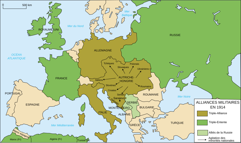
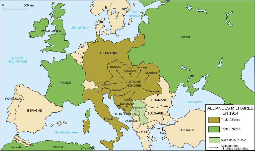
Deutsch: Karte von Militärbündnisse in Europa in 1914, (Französische)
English: Map of military alliances of Europe in 1914. (French)
Français : Carte des alliances militaires en Europe en 1914. (Français)
Русский: Схема военных альянсов в Европе в 1914 г. (фр.) |
||||||||
| Date | à 15:08 (UTC) | ||||||||
| Source |
Français : Création personnelle (version renommée de Image:Les rivalités en Europe en 1914.svg) |
||||||||
| Author | historicair | ||||||||
| Permission (Reusing this file) |
I, the copyright holder of this work, hereby publish it under the following licenses:
This file is licensed under the Creative Commons Attribution-Share Alike 2.5 Generic, 2.0 Generic and 1.0 Generic license.
You may select the license of your choice. |
||||||||
| Other versions |
[] .gif)
|


|
This SVG file contains embedded text that can be translated into your language, using any capable SVG editor, text editor or the SVG Translate tool. For more information see: About translating SVG files. |
File history
Click on a date/time to view the file as it appeared at that time.
| Date/Time | Thumbnail | Dimensions | User | Comment | |
|---|---|---|---|---|---|
| current | 12:27, 2 January 2015 | | 998 × 593 (98 KB) | Borodun (talk | contribs) | Moonsund archipelago is territory of Russia |
| 10:42, 13 January 2009 |  | 998 × 593 (98 KB) | Bibi Saint-Pol (talk | contribs) | typo | |
| 23:36, 26 February 2007 |  | 998 × 593 (98 KB) | Bibi Saint-Pol (talk | contribs) | {{Information |Description= {{fr|Carte des alliances militaires en Europe en 1914.}} |Source=Création personnelle (version renommée de Image:Les rivalités en Europe en 1914.svg) |Date=2006-10-31 |Author=historicair, 2006-31-10 |
You cannot overwrite this file.
File usage on Commons
The following 38 pages use this file:
- Atlas of World War I
- User:M0tty/WWI
- File:1914 ஐரோப்பியக் கூட்டணிகள்.svg
- File:1914년 유럽의 군사동맹지도.PNG
- File:Alliances militaires en Europe 1914-1918-hy.png
- File:Kaart Europa Bondgenootschappen.svg
- File:Map Europe alliances 1914-ar.svg
- File:Map Europe alliances 1914-az.svg
- File:Map Europe alliances 1914-bg.svg
- File:Map Europe alliances 1914-bn.svg
- File:Map Europe alliances 1914-ce.svg
- File:Map Europe alliances 1914-cs.svg
- File:Map Europe alliances 1914-de.svg
- File:Map Europe alliances 1914-el.svg
- File:Map Europe alliances 1914-en.svg
- File:Map Europe alliances 1914-eo.svg
- File:Map Europe alliances 1914-es.svg
- File:Map Europe alliances 1914-fr.svg
- File:Map Europe alliances 1914-gl.svg
- File:Map Europe alliances 1914-he.svg
- File:Map Europe alliances 1914-hr.svg
- File:Map Europe alliances 1914-hu.svg
- File:Map Europe alliances 1914-hy.jpg
- File:Map Europe alliances 1914-it.svg
- File:Map Europe alliances 1914-ko.svg
- File:Map Europe alliances 1914-la.svg
- File:Map Europe alliances 1914-lt.svg
- File:Map Europe alliances 1914-mk.svg
- File:Map Europe alliances 1914-nl.svg
- File:Map Europe alliances 1914-no.svg
- File:Map Europe alliances 1914-ro.svg
- File:Map Europe alliances 1914-sr.svg
- File:Map Europe alliances 1914-sv.svg
- File:Map Europe alliances 1914-ta.png
- File:Map Europe alliances 1914-uk.svg
- File:PotenciasEnLiza1914-pt.svg
- File:PotenciasEnLiza1914.svg
- Template:Other versions/Map Europe alliances 1914
File usage on other wikis
The following other wikis use this file:
- Usage on de.wikipedia.org
- Usage on fr.wikipedia.org
- Première Guerre mondiale
- Triplice
- Triple-Entente
- Alpes dinariques
- Relations entre l'Allemagne et la France
- Alliés de la Première Guerre mondiale
- Wikipédia:Atelier graphique/Images à améliorer/Archives/Mars 2008
- Pays impliqués dans la Première Guerre mondiale
- Front de l'Est (Première Guerre mondiale)
- Antonino Paternò-Castello
- Liste historique des régions et pays par PIB
- Wikipédia:Atelier graphique/Cartes/Archives/juillet 2012
- Utilisateur:Pablo31100/Les causes profondes de la première guerre mondiale
- Relations entre la France et la Russie
- Causes de la Première Guerre mondiale
- Alliance militaire
- Usage on fr.wikibooks.org
- Usage on fr.wikiversity.org
- Usage on it.wikipedia.org
- Usage on tt.wikipedia.org
- Usage on wo.wikipedia.org