File:Map Dusit.png
Jump to navigation
Jump to search

Size of this preview: 424 × 600 pixels. Other resolutions: 170 × 240 pixels | 339 × 480 pixels | 543 × 768 pixels | 724 × 1,024 pixels | 1,526 × 2,158 pixels.
Original file (1,526 × 2,158 pixels, file size: 1,023 KB, MIME type: image/png)
Captions
Captions
Add a one-line explanation of what this file represents
Summary[edit]
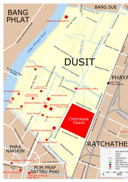
| Description | Map of Dusit District, Bangkok. |
| Date | |
| Source | Own creation |
| Author | Lerdsuwa |
| Permission (Reusing this file) |
GFDL |
| Other versions | Image:Map Dusit src eng.svg (SVG source) |
Licensing[edit]
I, the copyright holder of this work, hereby publish it under the following license:

|
Permission is granted to copy, distribute and/or modify this document under the terms of the GNU Free Documentation License, Version 1.2 or any later version published by the Free Software Foundation; with no Invariant Sections, no Front-Cover Texts, and no Back-Cover Texts. A copy of the license is included in the section entitled GNU Free Documentation License. |
| This file is licensed under the Creative Commons Attribution-Share Alike 3.0 Unported license. | ||
| ||
| This licensing tag was added to this file as part of the GFDL licensing update. |
File history
Click on a date/time to view the file as it appeared at that time.
| Date/Time | Thumbnail | Dimensions | User | Comment | |
|---|---|---|---|---|---|
| current | 02:10, 30 January 2020 | | 1,526 × 2,158 (1,023 KB) | Sodacan (talk | contribs) | Dusit Zoo is gone, Royal Turf Club is gone, National Assembly has moved to Sappaya-Sapasathan, Added Amphorn Sathan Villa |
| 08:37, 12 August 2011 |  | 1,526 × 1,869 (959 KB) | Lerdsuwa (talk | contribs) | Improve railway | |
| 15:58, 10 October 2006 |  | 1,526 × 1,869 (939 KB) | Lerdsuwa (talk | contribs) | == Summary == {{Information |Description=Map of Dusit District, Bangkok. |Source=Own creation |Date=10 October 2006 |Author=Lerdsuwa |Permission=GFDL |other_versions=Image:Map Dusit src eng.svg (SVG source) }} == Licensing == { |
You cannot overwrite this file.
File usage on Commons
The following 4 pages use this file:
File usage on other wikis
The following other wikis use this file:
- Usage on de.wikipedia.org
- Usage on fr.wikipedia.org
- Usage on it.wikipedia.org
- Usage on ms.wikipedia.org