File:Map Crusader states 1190-cs.svg
Jump to navigation
Jump to search

Size of this PNG preview of this SVG file: 440 × 599 pixels. Other resolutions: 176 × 240 pixels | 353 × 480 pixels | 564 × 768 pixels | 752 × 1,024 pixels | 1,505 × 2,048 pixels | 507 × 690 pixels.
Original file (SVG file, nominally 507 × 690 pixels, file size: 445 KB)
Captions
Captions
Add a one-line explanation of what this file represents
| Description |
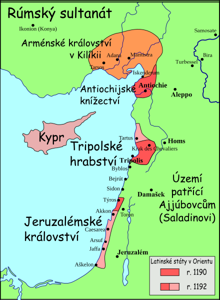
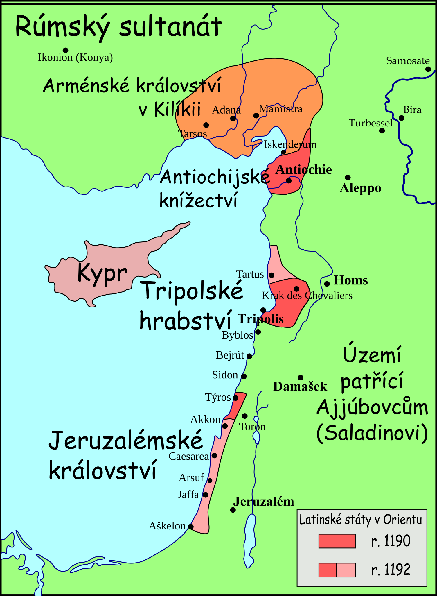
Français : Carte politique du Proche-Orient en 1197-1205
Čeština: Levanta v dobách třetí kruciáty |
| Date | (UTC) |
| Source | |
| Author |
|
| Other versions |
[]
See also[edit] |


| This is a retouched picture, which means that it has been digitally altered from its original version. The original can be viewed here: Map Crusader states 1190-fr.svg:
|
I, the copyright holder of this work, hereby publish it under the following licenses:
This file is licensed under the Creative Commons Attribution-Share Alike 3.0 Unported, 2.5 Generic, 2.0 Generic and 1.0 Generic license.
- You are free:
- to share – to copy, distribute and transmit the work
- to remix – to adapt the work
- Under the following conditions:
- attribution – You must give appropriate credit, provide a link to the license, and indicate if changes were made. You may do so in any reasonable manner, but not in any way that suggests the licensor endorses you or your use.
- share alike – If you remix, transform, or build upon the material, you must distribute your contributions under the same or compatible license as the original.

|
Permission is granted to copy, distribute and/or modify this document under the terms of the GNU Free Documentation License, Version 1.2 or any later version published by the Free Software Foundation; with no Invariant Sections, no Front-Cover Texts, and no Back-Cover Texts. A copy of the license is included in the section entitled GNU Free Documentation License. |
| This file is licensed under the Creative Commons Attribution-Share Alike 3.0 Unported license. | ||
| ||
| This licensing tag was added to this file as part of the GFDL licensing update. |
You may select the license of your choice.
Original upload log[edit]
This image is a derivative work of the following images:
- File:Levant_1190-fr.svg licensed with Cc-by-sa-3.0,2.5,2.0,1.0/nds, GFDL, GFDL/nds
- 2008-09-08T15:24:28Z Odejea 507x690 (623926 Bytes) {{Information |Description={{en|1=A political map of the [[w:en:Near East]] in 1190-1192 [[w:en:Common Era|CE]].}} {{fr|1=Carte politique du [[w:fr:Proche-Orient|Proche-Orient]] en 1197-1205}} |Source=travail personnel (own w
Uploaded with derivativeFX
File history
Click on a date/time to view the file as it appeared at that time.
| Date/Time | Thumbnail | Dimensions | User | Comment | |
|---|---|---|---|---|---|
| current | 11:29, 13 May 2009 | | 507 × 690 (445 KB) | Podzemnik (talk | contribs) | fixxed for second |
| 11:26, 13 May 2009 |  | 507 × 690 (400 KB) | Podzemnik (talk | contribs) | description fixxed | |
| 11:23, 13 May 2009 |  | 507 × 690 (133 KB) | Podzemnik (talk | contribs) | {{Information |Description={{en|1=A political map of the w:en:Near East in 1190-1192 CE.}} {{fr|1=Carte politique du Proche-Orient en 1197-1205}} {{cs|Levanta v dobách třetí kruciáty}} |Source=*[[:File:Le |
You cannot overwrite this file.
File usage on Commons
The following 17 pages use this file:
- File:Ciutats dels estats llatins2.png
- File:Levanta 1190-cs.svg (file redirect)
- File:Map Crusader states 1190-ar.svg
- File:Map Crusader states 1190-arz.png
- File:Map Crusader states 1190-cs.svg
- File:Map Crusader states 1190-de.svg
- File:Map Crusader states 1190-en.svg
- File:Map Crusader states 1190-es.svg
- File:Map Crusader states 1190-fa.svg
- File:Map Crusader states 1190-fr.svg
- File:Map Crusader states 1190-fr2.svg
- File:Map Crusader states 1190-he.svg
- File:Map Crusader states 1190-it.svg
- File:Map Crusader states 1190-ka.png
- File:Map Crusader states 1190-pt.svg
- File:Map Crusader states 1190-ru.svg
- Template:Other versions/Map Crusader states 1190
File usage on other wikis
The following other wikis use this file:
- Usage on cs.wikipedia.org