File:Manzanar War Relocation Historical Site Entrance.jpg
Original file (7,360 × 4,912 pixels, file size: 21.73 MB, MIME type: image/jpeg)
Captions
Summary[edit]
DescriptionManzanar War Relocation Historical Site Entrance.jpg |
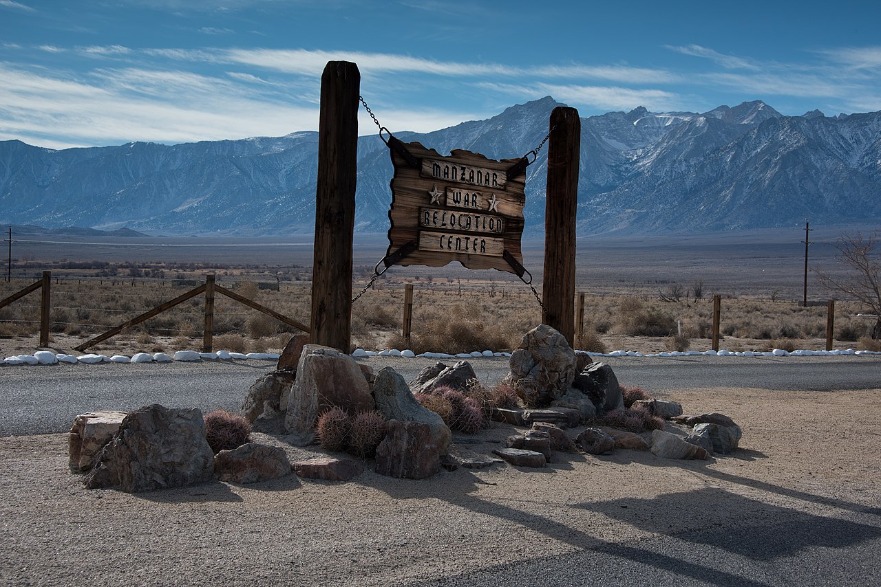
English: Manzanar War Relocation Center near Independence, California. One of California's locations for incarcerating persons of Japanese ancestry during the early years of World War 2.
日本語: カリフォルニア州インディペンデンス近郊のマンザナール戦争移転センター。 第二次世界大戦初期の日本人の祖先を監禁するカリフォルニアの場所の一つ。
|
||
Date | Taken on 27 December 2015, 13:16:04 | ||
Source | Own work | ||
Author | John R Savageau |
Camera location | 36° 43′ 37.48″ N, 118° 09′ 07.25″ W | View this and other nearby images on: OpenStreetMap | 36.727077; -118.152014 |
---|
In 1942, the United States government ordered more than 110,000 men, women, and children to leave their homes and detained them in remote, military-style camps. Manzanar War Relocation Center was one of ten camps where the US government incarcerated Japanese immigrants ineligible for citizenship and Japanese American citizens during World War II. (NPS)
Licensing[edit]
- You are free:
- to share – to copy, distribute and transmit the work
- to remix – to adapt the work
- Under the following conditions:
- attribution – You must give appropriate credit, provide a link to the license, and indicate if changes were made. You may do so in any reasonable manner, but not in any way that suggests the licensor endorses you or your use.
- share alike – If you remix, transform, or build upon the material, you must distribute your contributions under the same or compatible license as the original.
This image was uploaded as part of Wiki Loves Monuments 2021.
Afrikaans ∙ Alemannisch ∙ azərbaycanca ∙ Bahasa Indonesia ∙ Bahasa Melayu ∙ Bikol Central ∙ bosanski ∙ brezhoneg ∙ català ∙ čeština ∙ Cymraeg ∙ dansk ∙ davvisámegiella ∙ Deutsch ∙ eesti ∙ English ∙ español ∙ Esperanto ∙ euskara ∙ français ∙ Frysk ∙ Gaeilge ∙ galego ∙ hrvatski ∙ Ido ∙ italiano ∙ latviešu ∙ Lëtzebuergesch ∙ Malagasy ∙ magyar ∙ Malti ∙ Nederlands ∙ norsk ∙ norsk nynorsk ∙ norsk bokmål ∙ polski ∙ português ∙ português do Brasil ∙ română ∙ shqip ∙ sicilianu ∙ slovenčina ∙ slovenščina ∙ suomi ∙ svenska ∙ Tagalog ∙ Türkçe ∙ Yorùbá ∙ Zazaki ∙ Ελληνικά ∙ беларуская ∙ беларуская (тарашкевіца) ∙ български ∙ кыргызча ∙ македонски ∙ русский ∙ српски / srpski ∙ українська ∙ ქართული ∙ հայերեն ∙ नेपाली ∙ हिन्दी ∙ বাংলা ∙ മലയാളം ∙ ไทย ∙ 한국어 ∙ +/− |
File history
Click on a date/time to view the file as it appeared at that time.
Date/Time | Thumbnail | Dimensions | User | Comment | |
---|---|---|---|---|---|
current | 00:56, 9 October 2021 | 7,360 × 4,912 (21.73 MB) | Jrsavageau (talk | contribs) | Uploaded own work with UploadWizard |
You cannot overwrite this file.
File usage on Commons
There are no pages that use this file.
Metadata
This file contains additional information such as Exif metadata which may have been added by the digital camera, scanner, or software program used to create or digitize it. If the file has been modified from its original state, some details such as the timestamp may not fully reflect those of the original file. The timestamp is only as accurate as the clock in the camera, and it may be completely wrong.
Camera manufacturer | NIKON CORPORATION |
---|---|
Camera model | NIKON D810 |
Author | John R Savageau |
Copyright holder |
|
Exposure time | 1/250 sec (0.004) |
F-number | f/11 |
ISO speed rating | 100 |
Date and time of data generation | 13:16, 27 December 2015 |
Lens focal length | 62 mm |
Horizontal resolution | 240 dpi |
Vertical resolution | 240 dpi |
Software used | Adobe Photoshop Lightroom 6.3 (Windows) |
File change date and time | 08:23, 29 December 2015 |
Exposure Program | Aperture priority |
Exif version | 2.3 |
Date and time of digitizing | 13:16, 27 December 2015 |
APEX shutter speed | 7.965784 |
APEX aperture | 6.918863 |
APEX exposure bias | −1.3333333333333 |
Maximum land aperture | 4.5 APEX (f/4.76) |
Metering mode | Pattern |
Light source | Unknown |
Flash | Flash did not fire, compulsory flash suppression |
DateTimeOriginal subseconds | 31 |
DateTimeDigitized subseconds | 31 |
Focal plane X resolution | 2,048.4022216797 |
Focal plane Y resolution | 2,048.4022216797 |
Focal plane resolution unit | 3 |
Sensing method | One-chip color area sensor |
File source | Digital still camera |
Scene type | A directly photographed image |
Custom image processing | Normal process |
Exposure mode | Auto exposure |
White balance | Auto white balance |
Digital zoom ratio | 1 |
Focal length in 35 mm film | 62 mm |
Scene capture type | Standard |
Scene control | None |
Contrast | Normal |
Saturation | Normal |
Sharpness | Normal |
Subject distance range | Unknown |
Serial number of camera | 3037041 |
Lens used | 28.0-300.0 mm f/3.5-5.6 |
Date metadata was last modified | 00:23, 29 December 2015 |
Unique ID of original document | 78BF3B0B6B8B27C7B87BADD6C50CF9CA |
IIM version | 4 |
Structured data
Items portrayed in this file
depicts
some value
36°43'37.477"N, 118°9'7.250"W
0.004 second
11
62 millimetre
100
27 December 2015
- National Register of Historic Places with known IDs
- National Register of Historic Places missing SDC depicts
- National Register of Historic Places missing SDC location of creation
- United States photographs taken on 2015-12-27
- Files with coordinates missing SDC location of creation
- CC-BY-SA-4.0
- Self-published work
- Images from Wiki Loves Monuments 2021
- Images from Wiki Loves Monuments 2021 in the United States
- Images from Wiki Loves Monuments 2021 in California
- Images from Wiki Loves Monuments missing SDC depicts
- Images from Wiki Loves Monuments missing SDC location of creation
- Wiki Loves Monuments 2021 in the United States unreviewed
- Uploaded via Campaign:wlm-us
- Pages with maps