File:Mannersdorf am Leithagebirge - ehem. Klosterkirche St. Anna.JPG
Jump to navigation
Jump to search

Size of this preview: 800 × 533 pixels. Other resolutions: 320 × 213 pixels | 640 × 427 pixels | 1,024 × 683 pixels | 1,280 × 853 pixels | 2,560 × 1,707 pixels | 4,180 × 2,787 pixels.
Original file (4,180 × 2,787 pixels, file size: 9.92 MB, MIME type: image/jpeg)
Captions
Captions
Add a one-line explanation of what this file represents
Summary[edit]
| Description |
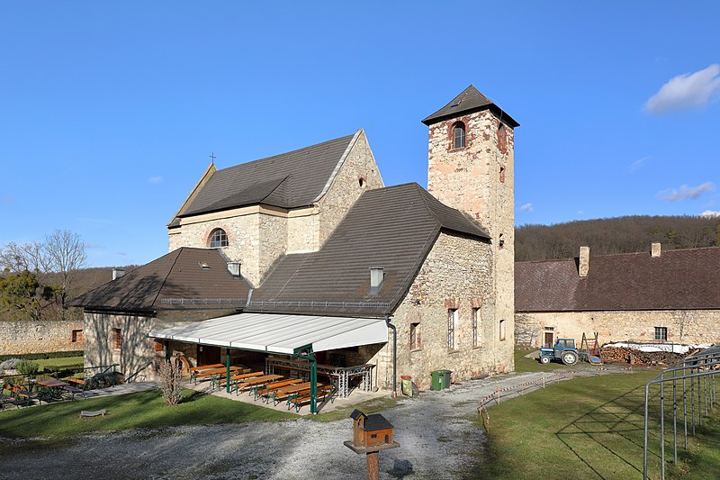
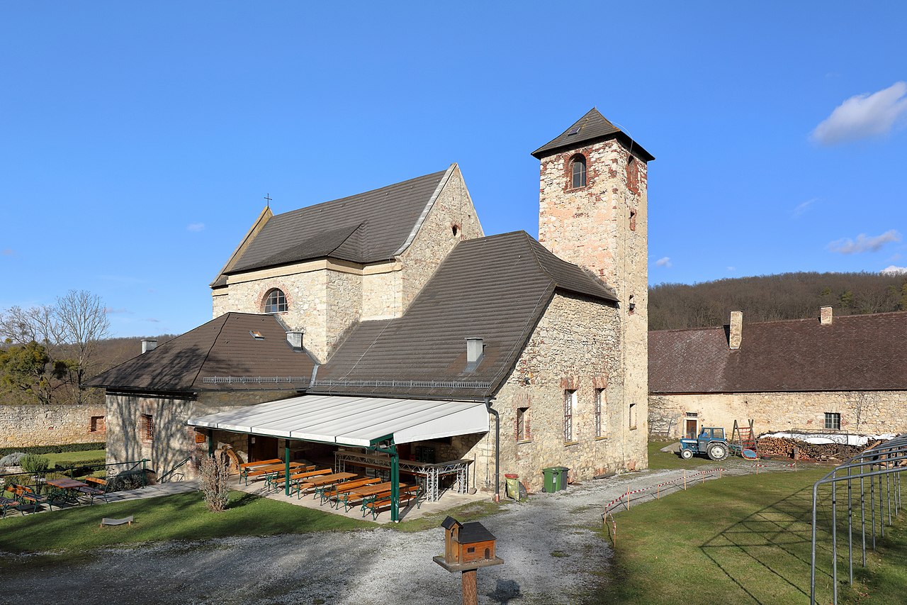
Deutsch: Die ehem. Kirche St. Anna im Naturpark Mannersdorf-Wüste in der niederösterreichischen Stadtgemeinde Mannersdorf am Leithagebirge. Sie war die Klosterkirche der ehem. Karmeliter-Einsiedelei „St. Anna in der Wüste“. Der Name „Wüste“ kommt vom griechischen Wort „eremos“, das „Wüste“ oder „Einsiedelei“ bedeutet.
Das Kloster wurde 1644 von der Witwe Kaiser Ferdinand, Eleonora von Mantua, gestiftet, 1654 fertiggestellt, 1683 von den Türken zerstört, wieder aufgebaut, 1783 von Kaiser Josef II. aufgelöst und verfiel danach. 1982/83 wurde das Gebiet wegen seiner landschaftlichen Schönheit zum Naturschutzpark „Die Wüste Mannersdorf“ erklärt und die Klosteranlage, deren Zentrum die „Klosterkirche St. Anna“ ist, renoviert. Der Naturschutzpark „Die Wüste Mannersdorf“ ist Teil des 803 ha großen „Landschaftsschutzgebietes Leithagebirge“. |
| Date | |
| Source | Own work |
| Author | C.Stadler/Bwag |
| Permission (Reusing this file) |
Deutsch: Hallo, du darfst mein Foto kostenlos nutzen, aber nenne mich bitte als Fotograf, beispielsweise „Foto: C.Stadler/Bwag“ oder © C.Stadler/Bwag; CC-BY-SA-4.0. Auf mehr Angaben bestehe ich nicht - im Gegensatz zu manch anderen, die die Vorgaben der unten angeführten Lizenzierung auf Punkt und Beistrich einfordern. English: Feel free to use my photos, but please mention me as the author like © C.Stadler/Bwag or © C.Stadler/Bwag; CC-BY-SA-4.0 (that's good enough) and if you want send me a message: bwag@gmx.net. |
| Object location | | View this and other nearby images on: OpenStreetMap |
|---|
| Camera location | | View this and other nearby images on: OpenStreetMap |
|---|
Licensing[edit]
I, the copyright holder of this work, hereby publish it under the following license:
This file is licensed under the Creative Commons Attribution-Share Alike 4.0 International license.
- You are free:
- to share – to copy, distribute and transmit the work
- to remix – to adapt the work
- Under the following conditions:
- attribution – You must give appropriate credit, provide a link to the license, and indicate if changes were made. You may do so in any reasonable manner, but not in any way that suggests the licensor endorses you or your use.
- share alike – If you remix, transform, or build upon the material, you must distribute your contributions under the same or compatible license as the original.
File history
Click on a date/time to view the file as it appeared at that time.
| Date/Time | Thumbnail | Dimensions | User | Comment | |
|---|---|---|---|---|---|
| current | 09:39, 31 January 2021 | | 4,180 × 2,787 (9.92 MB) | Bwag (talk | contribs) | {{Information |Description= {{de|1= Die ehem. Kirche St. Anna im Naturpark Mannersdorf-Wüste in der niederösterreichischen Stadtgemeinde Mannersdorf am Leithagebirge. Sie war die Klosterkirche der ehem. Karmeliter-Einsiedelei „St. Anna in der Wüste“. Der Name „Wüste“ kommt vom griechischen Wort „eremos“, das „Wüste“ oder „Einsiedelei“ bedeutet.<br/>Das Kloster wurde 1644 von der Witwe Kaiser Ferdinand, Eleonora von Mantua, gestiftet, 1654 fertiggestellt, 1683 von den Türken zerstört, wieder... |
You cannot overwrite this file.
File usage on Commons
The following 2 pages use this file:
File usage on other wikis
The following other wikis use this file:
- Usage on cs.wikipedia.org
- Usage on de.wikipedia.org
- Usage on en.wikipedia.org
- Usage on hu.wikipedia.org
- Usage on www.wikidata.org