File:Manhan Silver Lead Mining Co. Map of the property - btv1b8490833p.jpg
Jump to navigation
Jump to search

Size of this preview: 732 × 600 pixels. Other resolutions: 293 × 240 pixels | 586 × 480 pixels | 937 × 768 pixels | 1,250 × 1,024 pixels | 2,499 × 2,048 pixels | 6,983 × 5,722 pixels.
Original file (6,983 × 5,722 pixels, file size: 3.93 MB, MIME type: image/jpeg)
Captions
Captions
Add a one-line explanation of what this file represents
Summary[edit]
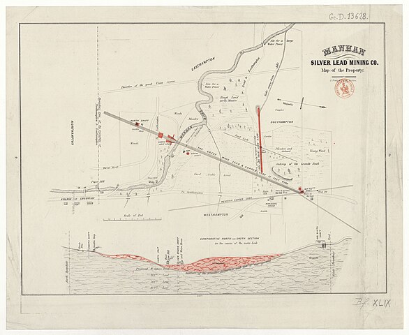
| Manhan Silver Lead Mining Co. Map of the property
( |
|||||||||||||||||||||||||||
|---|---|---|---|---|---|---|---|---|---|---|---|---|---|---|---|---|---|---|---|---|---|---|---|---|---|---|---|
| Title |
Manhan Silver Lead Mining Co. Map of the property |
||||||||||||||||||||||||||
| Description |
Français : Sujet : Mines
Southampton -- Mines Échelle(s) : Feet [1000 = 0m, 062 ; 1:5 000 environ] Couverture : États-Unis – Massachusetts Langue : anglais Éditeur : L. Prang a. Co. lith. (Boston) |
||||||||||||||||||||||||||
| Date | 19th century | ||||||||||||||||||||||||||
| Collection |
|
||||||||||||||||||||||||||
| References |
Français : Notice du catalogue : http://catalogue.bnf.fr/ark:/12148/cb40745199w |
||||||||||||||||||||||||||
| Source/Photographer |
Français : Bibliothèque nationale de France, département Cartes et plans, GE D-13628
Bibliothèque nationale de France |
||||||||||||||||||||||||||
| Permission (Reusing this file) |
|
||||||||||||||||||||||||||

File history
Click on a date/time to view the file as it appeared at that time.
| Date/Time | Thumbnail | Dimensions | User | Comment | |
|---|---|---|---|---|---|
| current | 10:40, 15 July 2022 | | 6,983 × 5,722 (3.93 MB) | Gzen92Bot (talk | contribs) | Gallica btv1b8490833p |
You cannot overwrite this file.
File usage on Commons
The following page uses this file: