File:Manette Bridge.png
Jump to navigation
Jump to search
No higher resolution available.
Manette_Bridge.png (338 × 194 pixels, file size: 22 KB, MIME type: image/png)
Captions
Captions
Add a one-line explanation of what this file represents

|
This city map image could be re-created using vector graphics as an SVG file. This has several advantages; see Commons:Media for cleanup for more information. If an SVG form of this image is available, please upload it and afterwards replace this template with
{{vector version available|new image name}}.
It is recommended to name the SVG file “Manette Bridge.svg”—then the template Vector version available (or Vva) does not need the new image name parameter. |
| Description |
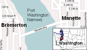
English: A map showing the location of the Manette Bridge. |
| Date | |
| Source | Self-made, used OpenStreetMap and :Image:Map of Washington counties |
| Author | OpenStreetMap |
Licensing[edit]
| Description |
This map was created from OpenStreetMap project data, collected by the community. This map may be incomplete, and may contain errors. Don't rely solely on it for navigation. |
| Date | (see file history) |
| Source | openstreetmap.org |
| Creator |
OpenStreetMap contributors |
| Permission (Reusing this file) |
OpenStreetMap data and maps are licensed under the Creative Commons Attribution-ShareAlike 2.0 license (CC-BY-SA 2.0). This file is licensed under the Creative Commons Attribution-Share Alike 2.0 Generic license.
|
| Georeferencing | If inappropriate please set warp_status = skip to hide. |
Original upload log[edit]
Transferred from en.wikipedia to Commons by Stepshep using CommonsHelper.
The original description page was here. All following user names refer to en.wikipedia.
- 2008-10-18 21:44 ComputerGuy 338×194× (22240 bytes) {{Information | Description = A map showing the location of the [[Manette Bridge]]. | Source = Self-made, used [[OpenStreetMap]] and [[:Image:Map of Washington counties, blank.svg]] | Date = {{subst:CURRENTMONTHNAME}} {{subst:CURRENTDAY}}, {{subst:CURRE
File history
Click on a date/time to view the file as it appeared at that time.
| Date/Time | Thumbnail | Dimensions | User | Comment | |
|---|---|---|---|---|---|
| current | 18:57, 1 April 2009 | | 338 × 194 (22 KB) | File Upload Bot (Magnus Manske) (talk | contribs) | {{BotMoveToCommons|en.wikipedia|year={{subst:CURRENTYEAR}}|month={{subst:CURRENTMONTHNAME}}|day={{subst:CURRENTDAY}}}} {{Information |Description={{en|A map showing the location of the en:Manette Bridge.}} |Source=Transferred from [http://en.wikipe |
You cannot overwrite this file.
File usage on Commons
There are no pages that use this file.