File:Malta topographic map.png
Jump to navigation
Jump to search
No higher resolution available.
Malta_topographic_map.png (765 × 499 pixels, file size: 93 KB, MIME type: image/png)
Captions
Captions
Add a one-line explanation of what this file represents
Summary[edit]
| Description |
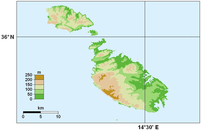
English: Topographic map of Malta. |
||
| Date | |||
| Source | |||
| Author |
Original by Hamelin de Guettelet. Retouched by Piroska. |
||
| Permission (Reusing this file) |
Hamelin de Guettelet, the copyright holder of this work, hereby publishes it under the following license:
|

File history
Click on a date/time to view the file as it appeared at that time.
| Date/Time | Thumbnail | Dimensions | User | Comment | |
|---|---|---|---|---|---|
| current | 01:48, 10 November 2008 | | 765 × 499 (93 KB) | Piroska (talk | contribs) | {{Information |Description={{en|1=Topographic map of Malta. Cutting out from Europe location Malte.png.}} |Source=Own work by uploader |Author=Piroska |Date=10th November 2008 |Permission={{self|FAL}} |
You cannot overwrite this file.
File usage on Commons
There are no pages that use this file.
File usage on other wikis
The following other wikis use this file:
- Usage on de.wikibooks.org
- Usage on en.wikipedia.org
- Usage on fa.wikipedia.org
- Usage on fi.wikipedia.org
- Usage on fr.wikipedia.org
- Usage on hu.wikipedia.org
- Usage on incubator.wikimedia.org
- Usage on ps.wikipedia.org
- Usage on vep.wikipedia.org