File:Mallorca topo.png
Jump to navigation
Jump to search

Size of this preview: 767 × 600 pixels. Other resolutions: 307 × 240 pixels | 614 × 480 pixels | 982 × 768 pixels | 1,280 × 1,001 pixels | 1,500 × 1,173 pixels.
Original file (1,500 × 1,173 pixels, file size: 934 KB, MIME type: image/png)
Captions
Captions
Add a one-line explanation of what this file represents
Summary[edit]
| Description |
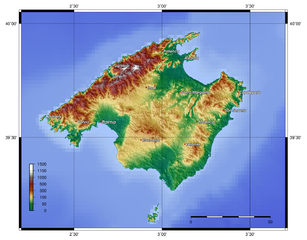
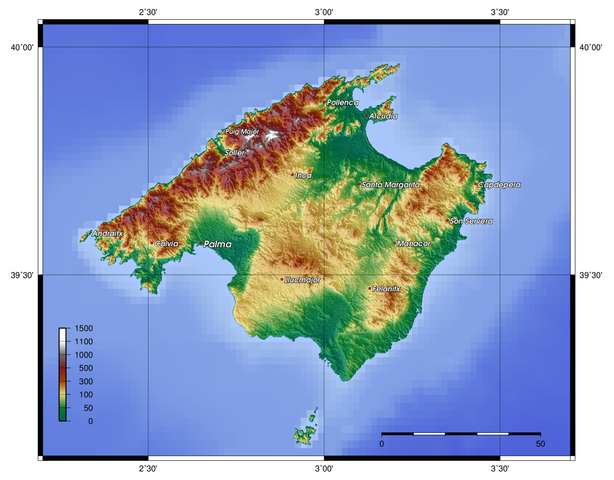
English: Mapa Topographic of Mallorca, created with GMT 4.1.3. |
| Date | 11.07.2006 |
| Source |
At least one of the following Public Domain data sources: |
| Author | Zamonin |
Licensing[edit]

|
Permission is granted to copy, distribute and/or modify this document under the terms of the GNU Free Documentation License, Version 1.2 or any later version published by the Free Software Foundation; with no Invariant Sections, no Front-Cover Texts, and no Back-Cover Texts. A copy of the license is included in the section entitled GNU Free Documentation License. |
| This file is licensed under the Creative Commons Attribution-Share Alike 3.0 Unported license. | ||
| ||
| This licensing tag was added to this file as part of the GFDL licensing update. |
File history
Click on a date/time to view the file as it appeared at that time.
| Date/Time | Thumbnail | Dimensions | User | Comment | |
|---|---|---|---|---|---|
| current | 16:29, 31 December 2012 | | 1,500 × 1,173 (934 KB) | Rotatebot (talk | contribs) | Bot: Image rotated by 180° |
| 09:16, 30 December 2012 |  | 1,500 × 1,173 (934 KB) | Rotatebot (talk | contribs) | Bot: Image rotated by 180° | |
| 13:26, 20 November 2012 |  | 1,500 × 1,173 (931 KB) | Zamonin (talk | contribs) | new labels | |
| 07:25, 8 May 2009 |  | 1,500 × 1,103 (893 KB) | Zamonin (talk | contribs) | added cities, mountains; used etopo1 instead of etopo2 | |
| 09:48, 7 May 2009 |  | 1,500 × 1,112 (904 KB) | Zamonin (talk | contribs) | (added cities used etopo1 instead of etopo2) | |
| 13:01, 12 July 2006 |  | 1,574 × 1,274 (1.74 MB) | Zamonin (talk | contribs) | Category:Maps of Spain == Description, Source == * Description: Topography of Mallorca, created with [http://gmt.soest.hawaii.edu/ GMT] 4.1.3 * Source: At least one of the following Public Domain data sources ** [http://http://dss.ucar.edu/datasets/ |
You cannot overwrite this file.
File usage on Commons
The following 2 pages use this file:
File usage on other wikis
The following other wikis use this file:
- Usage on bat-smg.wikipedia.org
- Usage on ca.wikipedia.org
- Usage on da.wikipedia.org
- Usage on de.wikipedia.org
- Usage on dsb.wikipedia.org
- Usage on el.wikipedia.org
- Usage on en.wikipedia.org
- Usage on fy.wikipedia.org
- Usage on hsb.wikipedia.org
- Usage on hu.wikipedia.org
- Usage on ja.wikipedia.org
- Usage on ko.wikipedia.org
- Usage on nds-nl.wikipedia.org
- Usage on nn.wikipedia.org
- Usage on scn.wikipedia.org
- Usage on www.wikidata.org
- Usage on zh.wikipedia.org