File:Malaysia tree diagram.svg
Jump to navigation
Jump to search

Size of this PNG preview of this SVG file: 512 × 384 pixels. Other resolutions: 320 × 240 pixels | 640 × 480 pixels | 1,024 × 768 pixels | 1,280 × 960 pixels | 2,560 × 1,920 pixels.
Original file (SVG file, nominally 512 × 384 pixels, file size: 95 KB)
Captions
Captions
Add a one-line explanation of what this file represents
Summary[edit]
| Description |
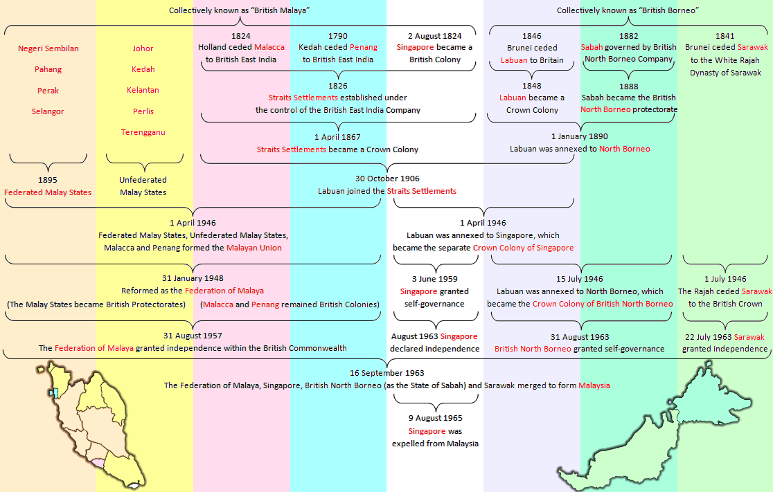
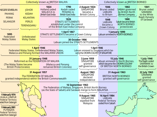
English: History of the evolution of Malaysia, redrawn as SVG. |
||
| Date | |||
| Source |
|
||
| Author | cmglee, Wdcf and Uwe Dedering | ||
| Other versions |

.png)

W3C-validity not checked.
Licensing[edit]
This file is licensed under the Creative Commons Attribution-Share Alike 3.0 Unported license.
- You are free:
- to share – to copy, distribute and transmit the work
- to remix – to adapt the work
- Under the following conditions:
- attribution – You must give appropriate credit, provide a link to the license, and indicate if changes were made. You may do so in any reasonable manner, but not in any way that suggests the licensor endorses you or your use.
- share alike – If you remix, transform, or build upon the material, you must distribute your contributions under the same or compatible license as the original.
File history
Click on a date/time to view the file as it appeared at that time.
| Date/Time | Thumbnail | Dimensions | User | Comment | |
|---|---|---|---|---|---|
| current | 00:49, 4 December 2016 | | 512 × 384 (95 KB) | AntiCompositeNumber (talk | contribs) | Change "SARAWAK granted independence" to "SARAWAK granted self-governance" based on w:Sarawak#Self-government and the Federation of Malaysia per a request at the English Wikipedia's w:WP:Graphics Lab |
| 14:23, 9 September 2014 |  | 512 × 384 (95 KB) | Cmglee (talk | contribs) | Use better map from Malaysia_location_map.svg | |
| 12:00, 7 September 2014 |  | 512 × 384 (61 KB) | Cmglee (talk | contribs) | Move map. | |
| 11:51, 7 September 2014 |  | 512 × 384 (61 KB) | Cmglee (talk | contribs) | Last one was better! | |
| 11:46, 7 September 2014 |  | 512 × 384 (61 KB) | Cmglee (talk | contribs) | Rinse and repeat... | |
| 11:41, 7 September 2014 |  | 512 × 384 (61 KB) | Cmglee (talk | contribs) | Try again... | |
| 11:33, 7 September 2014 |  | 512 × 384 (61 KB) | Cmglee (talk | contribs) | Fit text again. | |
| 11:22, 7 September 2014 |  | 512 × 384 (61 KB) | Cmglee (talk | contribs) | Uncondense text. | |
| 17:23, 5 September 2014 |  | 512 × 384 (60 KB) | Cmglee (talk | contribs) | Condense text. | |
| 17:14, 5 September 2014 |  | 512 × 384 (61 KB) | Cmglee (talk | contribs) | Add recent history (Federal Territories). |
You cannot overwrite this file.
File usage on Commons
The following 4 pages use this file:
File usage on other wikis
The following other wikis use this file:
- Usage on ar.wikipedia.org
- Usage on bn.wikipedia.org
- Usage on ca.wikipedia.org
- Usage on de.wikipedia.org
- Usage on el.wikipedia.org
- Usage on en.wikipedia.org
- Usage on es.wikipedia.org
- Usage on fr.wikipedia.org
- Usage on he.wikipedia.org
- Usage on hy.wikipedia.org
- Usage on ru.wikipedia.org
- Usage on ta.wikipedia.org
- Usage on th.wikipedia.org
- Usage on tr.wikipedia.org