File:Maharashtra locator map.png
Jump to navigation
Jump to search

Size of this preview: 800 × 583 pixels. Other resolutions: 320 × 233 pixels | 640 × 466 pixels | 1,024 × 746 pixels | 1,280 × 933 pixels | 2,560 × 1,866 pixels | 3,097 × 2,257 pixels.
Original file (3,097 × 2,257 pixels, file size: 878 KB, MIME type: image/png)
Captions
Captions
Add a one-line explanation of what this file represents
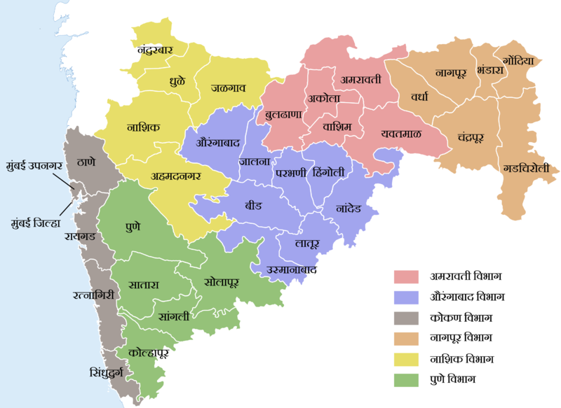
| Description | Locator map of the state of en:Maharashtra, India with district boundaries and administrative divisions |
| Date | (UTC) |
| Source | |
| Author |
|
| This is a retouched picture, which means that it has been digitally altered from its original version. Modifications: Colour coding as per divisions, and other clean up.. The original can be viewed here: Maharashtra locator map.svg:
|
This file is licensed under the Creative Commons Attribution-Share Alike 3.0 Unported license.
- You are free:
- to share – to copy, distribute and transmit the work
- to remix – to adapt the work
- Under the following conditions:
- attribution – You must give appropriate credit, provide a link to the license, and indicate if changes were made. You may do so in any reasonable manner, but not in any way that suggests the licensor endorses you or your use.
- share alike – If you remix, transform, or build upon the material, you must distribute your contributions under the same or compatible license as the original.
Original upload log[edit]
This image is a derivative work of the following images:
- File:Maharashtra_locator_map.svg licensed with Cc-by-sa-3.0
- 2008-12-21T12:11:22Z Planemad 2789x2232 (365545 Bytes) {{Information |Description= |Source= |Date= |Author= |Permission= |other_versions= }}
- 2008-12-21T12:08:04Z Planemad 2789x2232 (365091 Bytes) {{Information |Description={{en|1=map}} |Source=Own work by uploader |Author=[[User:PlaneMad|PlaneMad]] |Date= |Permission= |other_versions= }}
Uploaded with derivativeFX
File history
Click on a date/time to view the file as it appeared at that time.
| Date/Time | Thumbnail | Dimensions | User | Comment | |
|---|---|---|---|---|---|
| current | 18:57, 17 August 2011 | | 3,097 × 2,257 (878 KB) | Kaajawa (talk | contribs) | {{Information |Description=Locator map of the state of en:Maharashtra, India with district boundaries and administrative divisions |Source=*File:Maharashtra_locator_map.svg |Date=2011-08-17 18:48 (UTC) |Author=*[[:File:Maharashtra_l |
You cannot overwrite this file.
File usage on Commons
There are no pages that use this file.
File usage on other wikis
The following other wikis use this file:
- Usage on mr.wikibooks.org
- Usage on sa.wikipedia.org