File:Magellan Elcano Circumnavigation-fr.svg
Jump to navigation
Jump to search

Size of this PNG preview of this SVG file: 800 × 406 pixels. Other resolutions: 320 × 162 pixels | 640 × 325 pixels | 1,024 × 519 pixels | 1,280 × 649 pixels | 2,560 × 1,298 pixels | 2,246 × 1,139 pixels.
Original file (SVG file, nominally 2,246 × 1,139 pixels, file size: 258 KB)
Captions
Captions
Add a one-line explanation of what this file represents
Summary[edit]

Catalan

French

Romanian


| Description |
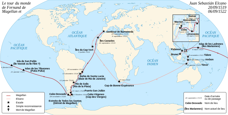
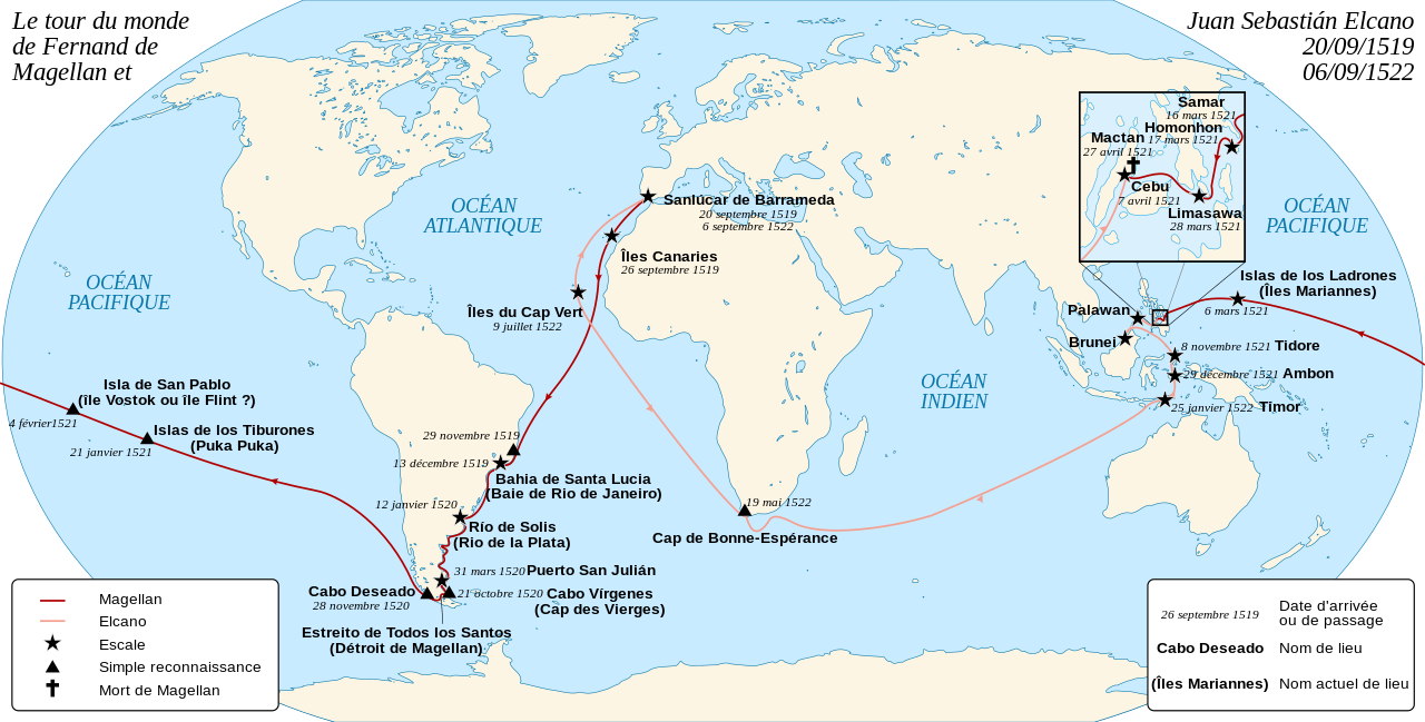
Català: Mapa de la primera circumnavegació del món, per Fernão de Magalhães i Juan Sebastián Elcano, de 1519 a 1522. English: French map of the first world circumnavigation of Ferdinand de Magellan and Juan Sebastián Elcano, from 1519 to 1522. Español: Mapa en francès de la primera circunnavegación del mundo, por Fernando de Magallanes y Juan Sebastián Elcano, de 1519 a 1522. Français : Carte de la première circumnavigation du monde, par Ferdinand de Magellan et Juan Sebastián Elcano, de 1519 à 1522. |
||
| Date | |||
| Source |
|
||
| Author | Sémhur | ||
| Other versions |
Derivative works of this file: |
||
| Attribution (required by the license) | © Sémhur / Wikimedia Commons / | ||
| SVG | W3C-validity not checked.
|
||
| Atelier graphique |

Licensing[edit]
I, the copyright holder of this work, hereby publish it under the following licenses:
| Copyleft: This work of art is free; you can redistribute it and/or modify it according to terms of the Free Art License. You will find a specimen of this license on the Copyleft Attitude site as well as on other sites. |
This file is licensed under the Creative Commons Attribution-Share Alike 4.0 International, 3.0 Unported, 2.5 Generic, 2.0 Generic and 1.0 Generic license.
- You are free:
- to share – to copy, distribute and transmit the work
- to remix – to adapt the work
- Under the following conditions:
- attribution – You must give appropriate credit, provide a link to the license, and indicate if changes were made. You may do so in any reasonable manner, but not in any way that suggests the licensor endorses you or your use.
- share alike – If you remix, transform, or build upon the material, you must distribute your contributions under the same or compatible license as the original.
You may select the license of your choice.
File history
Click on a date/time to view the file as it appeared at that time.
| Date/Time | Thumbnail | Dimensions | User | Comment | |
|---|---|---|---|---|---|
| current | 18:29, 29 September 2023 | | 2,246 × 1,139 (258 KB) | Joutbis (talk | contribs) | File uploaded using svgtranslate tool (https://svgtranslate.toolforge.org/). Added translation for ca. |
| 17:25, 28 February 2019 |  | 2,246 × 1,139 (219 KB) | Andrei Stroe (talk | contribs) | corrected some metadata related to the translation | |
| 17:11, 28 February 2019 |  | 2,246 × 1,139 (219 KB) | Andrei Stroe (talk | contribs) | Added Romanian language | |
| 18:29, 3 January 2013 |  | 2,246 × 1,139 (183 KB) | Sémhur (talk | contribs) | Suppression de Séville, et couleurs standards | |
| 17:22, 14 December 2012 |  | 2,246 × 1,139 (212 KB) | Sémhur (talk | contribs) | Ajout de Séville | |
| 15:16, 2 March 2008 |  | 2,246 × 1,139 (220 KB) | Sémhur (talk | contribs) | Correction d'un texte | |
| 16:18, 1 March 2008 |  | 2,246 × 1,139 (219 KB) | Sémhur (talk | contribs) | {{Information |Description= {{en|French map of the first world circumnavigation of Ferdinand de Magellan and Juan Sebastián Elcano, from 1519 to 1522.}} {{en|Carte de l |
You cannot overwrite this file.
File usage on Commons
The following 16 pages use this file:
- Fernão de Magalhães
- User:Adeletron 3030/botgalleries/Sports/2019 February 26-28
- User:Adeletron 3030/botgalleries/Sports/2023 September 28-30
- User:Chumwa/OgreBot/Potential transport maps/2019 February 19-28
- User:Chumwa/OgreBot/Transport Maps/2019 February 19-28
- User:Chumwa/OgreBot/Transport Maps/2023 September 21-30
- User:Chumwa/OgreBot/Travel and communication maps/2019 February 19-28
- User:Chumwa/OgreBot/Travel and communication maps/2023 September 21-30
- User:Magog the Ogre/Multilingual legend/2023 September 26-30
- User:OgreBot/Watercraft/2019 February 28
- File:First circumnavigation simplified.svg
- File:Magalhães Elcano Circum-navegação-pt.svg
- File:Magellan Elcano Circumnavigation-de.svg
- File:Magellan Elcano Circumnavigation-en.svg
- File:Magellan Elcano Circumnavigation-es.svg
- File:Magellan Elcano Circumnavigation-fr.svg
File usage on other wikis
The following other wikis use this file:
- Usage on an.wikipedia.org
- Usage on ca.wikipedia.org
- Usage on cs.wikipedia.org
- Usage on es.wikipedia.org
- Usage on fr.wikipedia.org
- Usage on fr.wikiversity.org
- Usage on mg.wikipedia.org
- Usage on oc.wikipedia.org
- Usage on ro.wikipedia.org
- Usage on tr.wikipedia.org