File:Madjarska okupacija Backe i Baranje, 1941-1944.png
Jump to navigation
Jump to search

Size of this preview: 615 × 600 pixels. Other resolutions: 246 × 240 pixels | 492 × 480 pixels | 886 × 864 pixels.
Original file (886 × 864 pixels, file size: 67 KB, MIME type: image/png)
Captions
Captions
Add a one-line explanation of what this file represents
Summary[edit]
| Description |
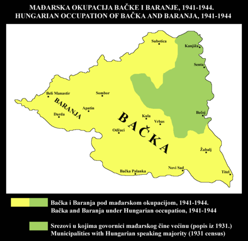
Srpski: Mađarska okupacija Bačke i Baranje, 1941-1944. Područje okupacije je upoređeno sa područjem srezova u kojima su govornici mađarskog bili u većini prema popisu iz 1931. Stanovništvo kojem maternji jezik nije bio mađarski činilo je većinu u najvećem delu ove teritorije koju je okupirala Mađarska. Korišćeni su podaci sa popisa iz 1931. iz ovog izvora: http://pod2.stat.gov.rs/ObjavljenePublikacije/G1931/Pdf/G19314001.pdf Jugoslovenske teritorije koje je u Drugom svetskom ratu okupirala Mađarska mogu se videti ovde: http://www.srpska-mreza.com/MAPS/Yugoslavia/YU-Nazi-division.jpg English: Hungarian occupation of Bačka and Baranja, 1941-1944. Area of occupation is compared with area of municipalities where speakers of Hungarian were in majority according to 1931 census. Population whose native language was not Hungarian formed the majority of inhabitants in most parts of this territory that was occupied by Hungary. I used 1931 census data from this source: http://pod2.stat.gov.rs/ObjavljenePublikacije/G1931/Pdf/G19314001.pdf Yugoslav territories occupied by Hungary in WW2 could be seen here: http://www.srpska-mreza.com/MAPS/Yugoslavia/YU-Nazi-division.jpg |
| Date | |
| Source | Own work |
| Author | PPetrovic |
| Other versions |
 |
Licensing[edit]
| I, the copyright holder of this work, release this work into the public domain. This applies worldwide. In some countries this may not be legally possible; if so: I grant anyone the right to use this work for any purpose, without any conditions, unless such conditions are required by law. |
File history
Click on a date/time to view the file as it appeared at that time.
| Date/Time | Thumbnail | Dimensions | User | Comment | |
|---|---|---|---|---|---|
| current | 11:15, 22 May 2014 | | 886 × 864 (67 KB) | PPetrovic (talk | contribs) | nova verzija |
| 18:32, 28 November 2012 |  | 886 × 864 (72 KB) | PANONIAN (talk | contribs) | revrted - this map is used in sr wikipedia. please upload your map version for en wikipedia under another filename | |
| 11:59, 28 November 2012 |  | 795 × 583 (30 KB) | DIREKTOR (talk | contribs) | De-greenified the yellow. | |
| 11:44, 28 November 2012 |  | 795 × 583 (28 KB) | DIREKTOR (talk | contribs) | Removed caption | |
| 21:36, 27 January 2011 |  | 886 × 864 (72 KB) | PPetrovic (talk | contribs) | {{Information |Description=Hungarian occupation of Bačka and Baranja, 1941-1944. Area of occupation is compared with area of municipalities where speakers of Hungarian were in majority according to 1931 census. Population whose native language was not Hu |
You cannot overwrite this file.
File usage on Commons
The following 2 pages use this file:
File usage on other wikis
The following other wikis use this file:
- Usage on sh.wikipedia.org
- Usage on sr.wikipedia.org
Categories:
- Maps of Yugoslavia during World War II
- Maps of Serbia during World War II
- Maps of the history of Vojvodina
- Maps of the history of Bačka
- Maps of the history of Baranja
- Historical maps of languages in Serbia
- Historical maps of languages in Vojvodina
- Serbian-language maps
- English-language linguistic maps of the Hungarian language
- Serbo-Croatian-language linguistic maps of the Hungarian language