File:Madeira 71.jpg
Jump to navigation
Jump to search

Size of this preview: 800 × 447 pixels. Other resolutions: 320 × 179 pixels | 640 × 357 pixels | 1,024 × 572 pixels | 1,280 × 715 pixels | 1,844 × 1,030 pixels.
Original file (1,844 × 1,030 pixels, file size: 324 KB, MIME type: image/jpeg)
Captions
Captions
Add a one-line explanation of what this file represents
Summary[edit]
| Description |
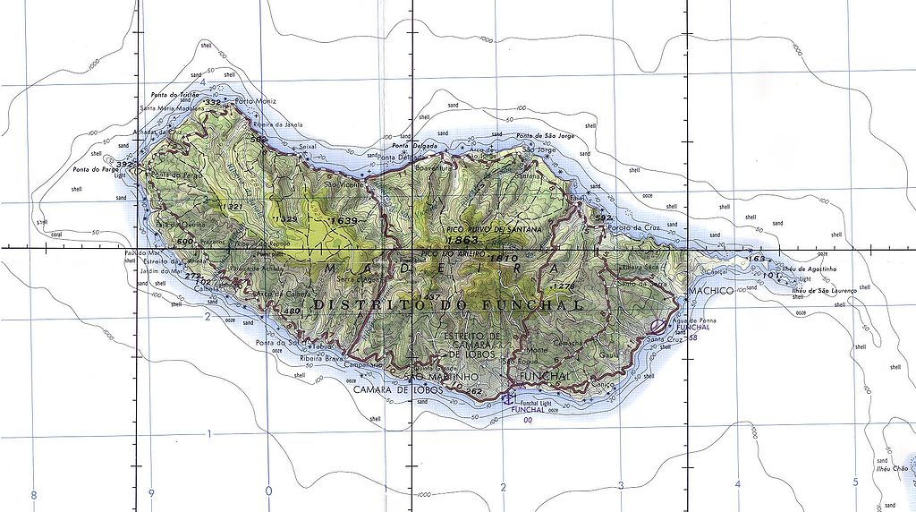
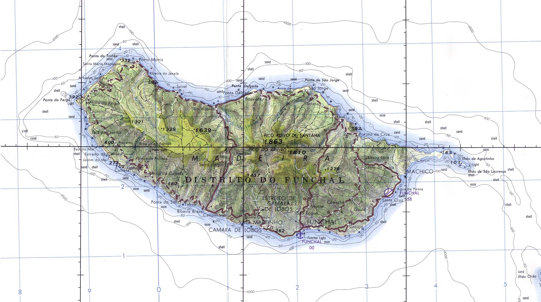
English: Madeira (Portugal) Original scale 1:250,000. Portion of Joint Operations Graphic (Ground) sheet NI 28-13, U.S. Defense Mapping Agency 1976 (325K) Not for navigational use |
| Date | |
| Source | Madeira (Portugal) (Aeronautical Chart) Original scale 1:250,000. Portion of Joint Operations Graphic (Ground) sheet NI 28-13, U.S. Defense Mapping Agency 1976 from Perry-Castañeda Library Map Collection: Polar Regions and Oceans Maps |
| Author | U.S. Defense Mapping Agency |
| Permission (Reusing this file) |
Public domain |
Licensing[edit]
This image is a work of a U.S. military or Department of Defense employee, taken or made as part of that person's official duties. As a work of the U.S. federal government, the image is in the public domain in the United States.
|
 |
File history
Click on a date/time to view the file as it appeared at that time.
| Date/Time | Thumbnail | Dimensions | User | Comment | |
|---|---|---|---|---|---|
| current | 07:30, 8 February 2005 | | 1,844 × 1,030 (324 KB) | Davenbelle~commonswiki (talk | contribs) | # Madeira (Portugal) Original scale 1:250,000. Portion of Joint Operations Graphic (Ground) sheet NI 28-13, U.S. Defense Mapping Agency 1976 (325K) Not for navigational use |
You cannot overwrite this file.
File usage on Commons
The following 17 pages use this file:
- User:Enyavar/DiscussingMaps
- File:Nossa Senhora com o Menino, São Bento e São Bernardo Francisco Henriques atribuido (cropped).jpg
- Category:Airports in Madeira
- Category:Animals of Madeira
- Category:Banana plantations in Madeira
- Category:Cableways in Madeira
- Category:Flora of Madeira
- Category:Forestry in Madeira
- Category:Lighthouses in Madeira
- Category:Madeira
- Category:Maps of Madeira
- Category:People of Madeira
- Category:Pollution in Madeira
- Category:Social problems of Madeira
- Category:Views of Madeira
- Category:Water transport in Madeira
- Category:Zebra crossings in Madeira
.jpg)
File usage on other wikis
The following other wikis use this file:
- Usage on als.wikipedia.org
- Usage on an.wikipedia.org
- Usage on ar.wikipedia.org
- Usage on arz.wikipedia.org
- Usage on ast.wikipedia.org
- Usage on ca.wikipedia.org
- Usage on ce.wikipedia.org
- Usage on cs.wikipedia.org
- Usage on cv.wikipedia.org
- Usage on cy.wikipedia.org
- Usage on de.wikipedia.org
- Usage on diq.wikipedia.org
- Usage on en.wikivoyage.org
- Usage on eo.wikipedia.org
- Usage on es.wikipedia.org
- Usage on eu.wikipedia.org
- Usage on fi.wiktionary.org
- Usage on fr.wikipedia.org
- Usage on fr.wikivoyage.org
- Usage on fy.wikipedia.org
- Usage on ga.wikipedia.org
- Usage on gd.wikipedia.org
- Usage on gl.wikipedia.org
- Usage on he.wikipedia.org
- Usage on hu.wikipedia.org
- Usage on hy.wikipedia.org
- Usage on ia.wikipedia.org
- Usage on ig.wikipedia.org
- Usage on lt.wikipedia.org
- Usage on nap.wikipedia.org
- Usage on nds-nl.wikipedia.org
- Usage on nl.wikinews.org
- Usage on nn.wikipedia.org
- Usage on no.wikipedia.org
- Usage on oc.wikipedia.org
- Usage on pl.wikipedia.org
- Usage on ru.wikipedia.org
- Usage on scn.wikipedia.org
- Usage on sr.wikipedia.org
- Usage on stq.wikipedia.org
- Usage on sv.wikipedia.org
- Usage on sw.wikipedia.org
- Usage on tg.wikipedia.org
- Usage on tr.wikipedia.org
View more global usage of this file.