File:Mackinac Island topographic map-en.svg
Jump to navigation
Jump to search

Size of this PNG preview of this SVG file: 545 × 600 pixels. Other resolutions: 218 × 240 pixels | 436 × 480 pixels | 698 × 768 pixels | 931 × 1,024 pixels | 1,862 × 2,048 pixels | 1,200 × 1,320 pixels.
Original file (SVG file, nominally 1,200 × 1,320 pixels, file size: 457 KB)
Captions
Captions
Add a one-line explanation of what this file represents
Summary[edit]
| Camera location | | View this and other nearby images on: OpenStreetMap |
|---|
| Description |
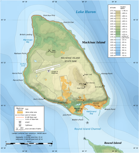
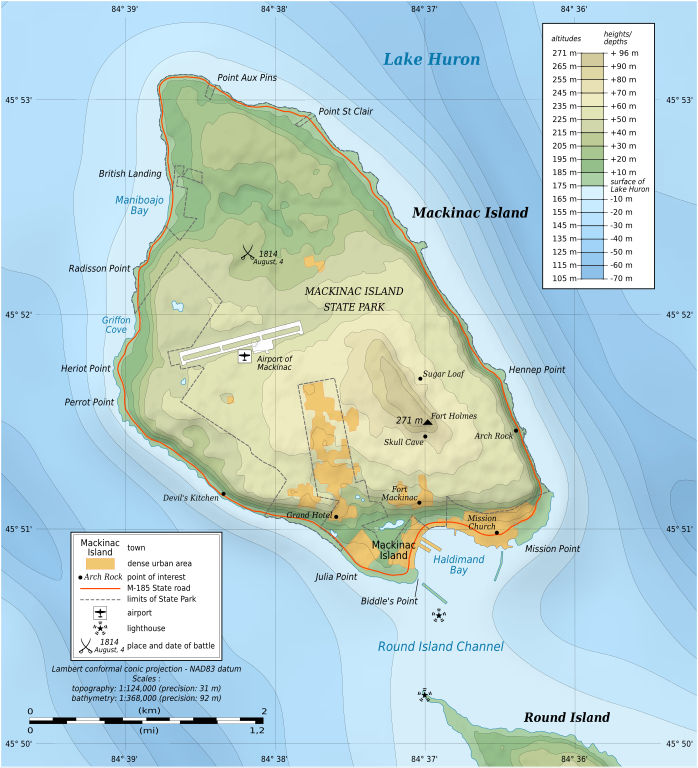
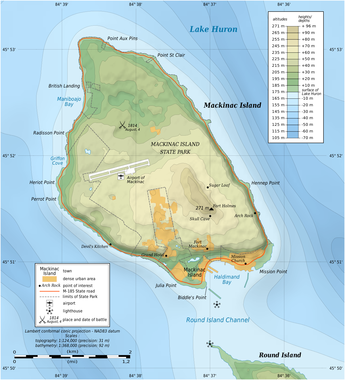
English: Topographic map in English of Mackinac Island, Lake Huron, Michigan, USA.
Note: The shaded relief is a raster image embedded in the SVG file. Français : Carte topographique en anglais de l'Île Mackinac, Lac Huron, Michigan, États-Unis. Note : Les ombres du relief sont une image bitmap embarquée dans le fichier SVG. Lambert conformal conic projection – NAD83 datum
|
||
| Date | |||
| Source |
Own work
|
||
| Author | Eric Gaba (Sting - fr:Sting) | ||
| Permission (Reusing this file) |
|
||
| Other versions |
|


|
This SVG file contains embedded text that can be translated into your language, using any capable SVG editor, text editor or the SVG Translate tool. For more information see: About translating SVG files. |
Licensing[edit]
I, the copyright holder of this work, hereby publish it under the following licenses:

|
Permission is granted to copy, distribute and/or modify this document under the terms of the GNU Free Documentation License, Version 1.2 or any later version published by the Free Software Foundation; with no Invariant Sections, no Front-Cover Texts, and no Back-Cover Texts. A copy of the license is included in the section entitled GNU Free Documentation License. |
This file is licensed under the Creative Commons Attribution-Share Alike 3.0 Unported license.
- You are free:
- to share – to copy, distribute and transmit the work
- to remix – to adapt the work
- Under the following conditions:
- attribution – You must give appropriate credit, provide a link to the license, and indicate if changes were made. You may do so in any reasonable manner, but not in any way that suggests the licensor endorses you or your use.
- share alike – If you remix, transform, or build upon the material, you must distribute your contributions under the same or compatible license as the original.
You may select the license of your choice.
File history
Click on a date/time to view the file as it appeared at that time.
| Date/Time | Thumbnail | Dimensions | User | Comment | |
|---|---|---|---|---|---|
| current | 17:43, 7 July 2010 | | 1,200 × 1,320 (457 KB) | Liandrei (talk | contribs) | fix |
| 17:39, 7 July 2010 |  | 1,196 × 1,316 (133 KB) | Liandrei (talk | contribs) | fix | |
| 17:35, 7 July 2010 |  | 1,196 × 1,316 (133 KB) | Liandrei (talk | contribs) | Removed border | |
| 01:37, 9 June 2009 |  | 1,200 × 1,320 (462 KB) | Sting (talk | contribs) | == Summary == {{Location|45|51|53|N|84|37|30|W|scale:30000}} {{Information| |Description={{en|Topographic map in English of Mackinac Island, Lake Huron, Michigan, USA.<br/>''Note: The shaded relief is a raster image embedded in th |
You cannot overwrite this file.
File usage on Commons
The following 3 pages use this file:
File usage on other wikis
The following other wikis use this file:
- Usage on ca.wikipedia.org
- Usage on de.wikipedia.org
- Usage on en.wikipedia.org
- Mackinac Island
- Fort Mackinac
- Fort Holmes
- Mackinac Island State Park
- Andrew Holmes (army officer)
- Battle of Mackinac Island (1814)
- Mission House (Mackinac Island)
- Arch Rock (Mackinac Island)
- Round Island Light, Michigan
- Marquette Park (Mackinac Island)
- Round Island Passage Light
- Wikipedia:Graphics Lab/Photography workshop/Archive/Jul 2010
- Portal:Islands/Selected article
- Portal:Islands/Selected article/55
- Usage on en.wikivoyage.org
- Usage on es.wikipedia.org
- Usage on fr.wikipedia.org
- Usage on ja.wikipedia.org
- Usage on kk.wikipedia.org
- Usage on nl.wikipedia.org
- Usage on pl.wikipedia.org
- Usage on ru.wikipedia.org
- Usage on www.wikidata.org
- Usage on xmf.wikipedia.org
- Usage on zh.wikipedia.org