File:Mackenzie River, Canada ESA23484305.jpeg

Original file (6,577 × 7,294 pixels, file size: 29.22 MB, MIME type: image/jpeg)
Captions
Captions
Summary[edit]
| Description |
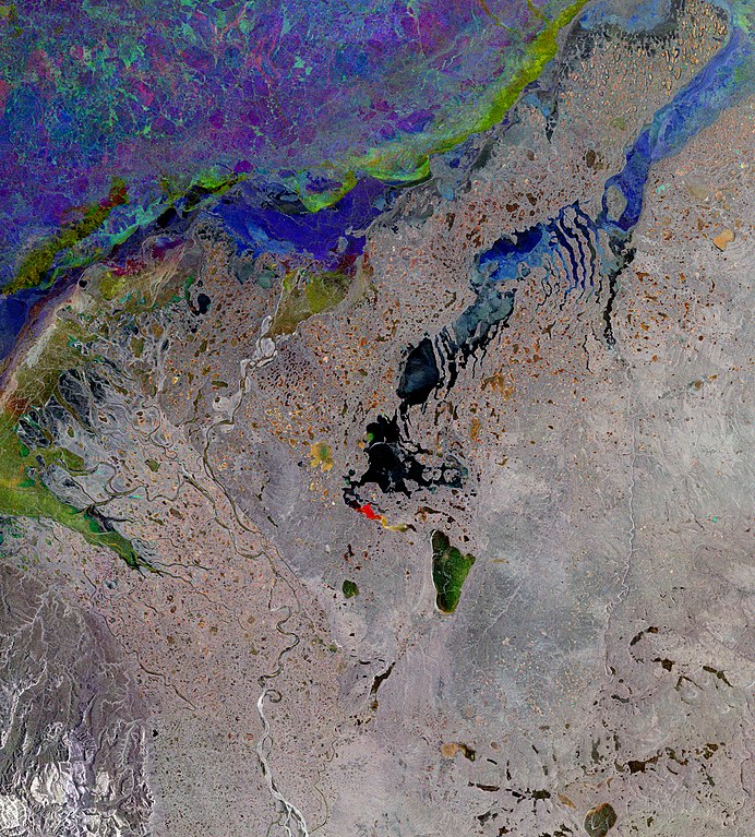
English: The Copernicus Sentinel-1 mission takes us over the Mackenzie River, a major river system in the Canadian boreal forest. Its basin is the largest in Canada and is the second largest drainage basin of any North American river, after the Mississippi. Zoom in to see this image at its full resolution or click on the circles to learn more about the features in it. The Mackenzie River flows through a vast region of forest and tundra through the Northwest Territories from the Great Slave Lake to the Beaufort Sea in the Arctic Ocean. Its delta covers an area around 12 000 sq km, measuring more than 190 km from north to south and is around 80 km wide along the Arctic shore. The maze of branching and intertwining channels is dotted with numerous lakes and ponds. This wintery, radar image combines three radar acquisitions from the Copernicus Sentinel-1 mission to show changes in land and water surfaces between three acquisition dates: 18 November 2019, 5 December 2019 and 10 January 2020. In the top of the image, parts of the frozen Arctic Ocean can be seen. The different colours are due to the movement and cracking of sea ice between the acquisition dates. The landscape pictured here is very typical for these latitudes, with the whole region subject to a harsh winter climate. Many of the lakes are frozen during the winter months, with the exception of some of the lakes visible in black in the centre of the image, which are ice-free. One of the lakes appears red most likely due to new ice which has formed between image acquisitions. The town of Inuvik lies along the east channel of the Mackenzie River delta, around 100 km from the Arctic Ocean and approximately 200 km north of the Arctic Circle. The hamlet of Tuktoyaktuk lies on the shores of the Arctic Ocean and is the only community in Canada on the Arctic Ocean that is connected to the rest of Canada by road. Around 75% of the Mackenzie basin sits within a permafrost area. Permafrost, ground which remains completely frozen for at least two consecutive years, is common in high latitude regions. With increasing temperatures causing permafrost to thaw, it not only releases methane and carbon dioxide into the atmosphere, but it can cause erosion, flooding and landslides. Satellite data can be used to map permafrost, even in remote and inaccessible areas such as the Mackenzie River delta. The maps, using data from ESA’s Climate Change Initiative, are the longest, satellite-derived permafrost record currently available. This image is also featured on the Earth from Space video programme. |
| Date | 1 October 2021 (upload date) |
| Source | Mackenzie River, Canada |
| Author | European Space Agency |
| Other versions |
|
| Activity | Observing the Earth |
| Mission | Sentinel-1 |
| Set | Earth observation image of the week |
| System | Copernicus |

Licensing[edit]

|
This image contains data from a satellite in the Copernicus Programme, such as Sentinel-1, Sentinel-2 or Sentinel-3. Attribution is required when using this image.
Attribution: Contains modified Copernicus Sentinel data 2019-20
The use of Copernicus Sentinel Data is regulated under EU law (Commission Delegated Regulation (EU) No 1159/2013 and Regulation (EU) No 377/2014). Relevant excerpts:
Free access shall be given to GMES dedicated data [...] made available through GMES dissemination platforms [...].
Access to GMES dedicated data [...] shall be given for the purpose of the following use in so far as it is lawful:
GMES dedicated data [...] may be used worldwide without limitations in time.
GMES dedicated data and GMES service information are provided to users without any express or implied warranty, including as regards quality and suitability for any purpose. |
This media was created by the European Space Agency (ESA).
Where expressly so stated, images or videos are covered by the Creative Commons Attribution-ShareAlike 3.0 IGO (CC BY-SA 3.0 IGO) licence, ESA being an Intergovernmental Organisation (IGO), as defined by the CC BY-SA 3.0 IGO licence. The user is allowed under the terms and conditions of the CC BY-SA 3.0 IGO license to Reproduce, Distribute and Publicly Perform the ESA images and videos released under CC BY-SA 3.0 IGO licence and the Adaptations thereof, without further explicit permission being necessary, for as long as the user complies with the conditions and restrictions set forth in the CC BY-SA 3.0 IGO licence, these including that:
See the ESA Creative Commons copyright notice for complete information, and this article for additional details.
|
 | |
This file is licensed under the Creative Commons Attribution-ShareAlike 3.0 IGO license. Attribution: ESA, CC BY-SA IGO 3.0
| ||
File history
Click on a date/time to view the file as it appeared at that time.
| Date/Time | Thumbnail | Dimensions | User | Comment | |
|---|---|---|---|---|---|
| current | 09:01, 1 October 2021 | | 6,577 × 7,294 (29.22 MB) | OptimusPrimeBot (talk | contribs) | #Spacemedia - Upload of https://www.esa.int/var/esa/storage/images/esa_multimedia/images/2021/10/mackenzie_river_canada/23484295-1-eng-GB/Mackenzie_River_Canada.jpg via Commons:Spacemedia |
You cannot overwrite this file.
File usage on Commons
The following 2 pages use this file: