File:MUTCD usage by country.png
Jump to navigation
Jump to search

Size of this preview: 800 × 421 pixels. Other resolutions: 320 × 169 pixels | 640 × 337 pixels | 1,024 × 539 pixels | 1,280 × 674 pixels | 2,560 × 1,349 pixels | 6,460 × 3,403 pixels.
Original file (6,460 × 3,403 pixels, file size: 2.26 MB, MIME type: image/png)
Captions
Captions
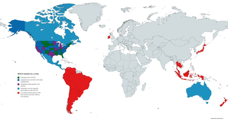
This map displays the world MUTCD usage, adoption or influence
Summary[edit]
| Description |
English: This map displays the usage, adoption or influence of MUTCD by country.
Français : Cette carte affiche l'utilisation, l'adoption ou l'influence du MUTCD par pays.
Español: Este mapa muestra el uso, la adopción o la influencia de MUTCD por país.
Deutsch: Diese Karte zeigt die Verwendung, Annahme oder den Einfluss von MUTCD nach Ländern.
Italiano: Questa mappa mostra l'utilizzo, l'adozione o l'influenza del MUTCD per paese.
Português: Este mapa exibe o uso, adoção ou influência do MUTCD por país.
Nederlands: Deze kaart toont het gebruik, de acceptatie of de invloed van MUTCD per land.
Русский: На этой карте показано использование, принятие или влияние MUTCD по странам.
日本語: このマップは、国ごとのMUTCDの使用、採用、または影響を示しています。
한국어: 이 지도는 국가별 MUTCD의 사용, 채택 또는 영향을 표시합니다.
中文(简体):该地图按国家/地区显示了MUTCD的使用、采用或影响。
中文(繁體):該地圖按國家/地區顯示了MUTCD的使用、採用或影響。
Tiếng Việt: Bản đồ này hiển thị việc sử dụng, áp dụng hoặc ảnh hưởng của MUTCD theo quốc gia.
हिन्दी: यह मानचित्र देश द्वारा MUTCD के उपयोग, अपनाने या प्रभाव को प्रदर्शित करता है।
Tagalog: Ipinapakita ng mapa na ito ang paggamit, pag-aampon o impluwensya ng MUTCD ayon sa bansa.
Türkçe: Bu harita, MUTCD'nin ülkeye göre kullanımını, benimsenmesini veya etkisini gösterir.
Ελληνικά: Αυτός ο χάρτης εμφανίζει τη χρήση, την υιοθέτηση ή την επιρροή του MUTCD ανά χώρα.
Svenska: Den här kartan visar användningen, adoptionen eller inflytandet av MUTCD per land. |
| Date | |
| Source | Own work based on the FHWA website regarding the adoption of MUTCD in the USA ([1]) plus various sources of international MUTCD such as AS 1742. |
| Author | Kunhill Road Signage |
![[1]](https://mutcd.fhwa.dot.gov/resources/images/states/statesmutcdmap.gif)
Licensing[edit]
This file is licensed under the Creative Commons Attribution-Share Alike 4.0 International license.
- You are free:
- to share – to copy, distribute and transmit the work
- to remix – to adapt the work
- Under the following conditions:
- attribution – You must give appropriate credit, provide a link to the license, and indicate if changes were made. You may do so in any reasonable manner, but not in any way that suggests the licensor endorses you or your use.
- share alike – If you remix, transform, or build upon the material, you must distribute your contributions under the same or compatible license as the original.
File history
Click on a date/time to view the file as it appeared at that time.
| Date/Time | Thumbnail | Dimensions | User | Comment | |
|---|---|---|---|---|---|
| current | 20:26, 24 November 2022 | | 6,460 × 3,403 (2.26 MB) | Kunhill Road Signage (talk | contribs) | Uploaded a work by Kunhill Road Signage from Own work based on the FHWA website regarding the adoption of MUTCD in the USA ([https://mutcd.fhwa.dot.gov/resources/images/states/statesmutcdmap.gif]) plus various sources of international MUTCD such as AS 1742. with UploadWizard |
You cannot overwrite this file.
File usage on Commons
There are no pages that use this file.
File usage on other wikis
The following other wikis use this file:
- Usage on en.wikipedia.org